| WPC Met Watch |
|
|
Mesoscale Precipitation Discussion: #0342 (2023) |
|
(Issued at 323 AM EDT Fri May 26 2023
) |
|
| MPD Selection |
|
|
|
|
|

Mesoscale Precipitation Discussion 0342
NWS Weather Prediction Center College Park MD
323 AM EDT Fri May 26 2023

Areas affected...eastern NM into the TX Panhandle

Concerning...Heavy rainfall...Flash flooding likely

Valid 260722Z - 261300Z

SUMMARY...At least a localized flash flood threat is likely to
continue over portions of eastern NM, possibly extending into the
TX Panhandle over the next few hours. Rainfall rates of at least
1-2 in/hr are expected with additional totals of 2-4 inches
through 13Z, but locally higher totals cannot be ruled out.

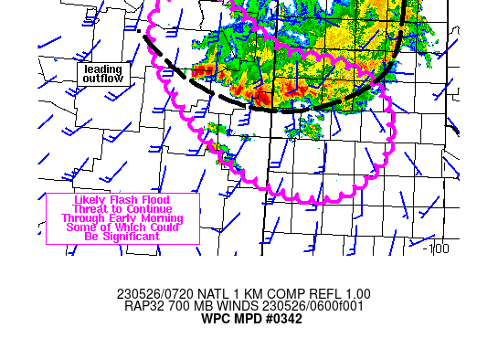
DISCUSSION...An MCS was located over the northern TX Panhandle
into eastern NM at 0645Z with an MCV located in Hansford County.
The leading edge of the associated outflow boundary has been
moving fairly steadily to the east/southeast across the TX
Panhandle but where the outflow boundary aligned with the mean
steering flow in eastern NM, slower movement was observed along
with significant training of heavy rain on either side of I-40,
extending back into eastern San Miguel County. MRMS estimates of
rainfall over Quay County in eastern NM ranged from 5-10 inches
over the past 6 hours ending at 07Z. While those values could be
too high given the presence of large hail and a lack of data from
the 88D at KFDX and surface stations makes ground truth of
rainfall difficult, a Wunderground.com local weather station in
eastern Quay County, just north of I-40, reported 1 inch of rain
in 30 minutes ending 0645Z, translating into peak rainfall rates
of at least 2 in/hr across the region given higher hourly rainfall
estimates to the south of the Wunderground station.

500-1500 J/kg MLCAPE was estimated just south of the outflow
boundary in eastern NM via the SPC mesoanalysis. 700 mb flow from
the RAP was 20-30 kt, oriented perpendicular to the western
portion of the outflow boundary in NM, with mean cell translation
toward the southeast but upstream development was promoting
training. Short term forecasts from the RAP suggest 700 mb winds
weakening into the 15-20 kt range through 13Z but lingering
overrunning flow and available instability should continue
training of cells just north out the outflow boundary over some of
the same regions currently experiencing flash flooding for another
1-3 hours but some questions remain with organization beyond 10Z.
With rainfall rates of at least 1-2 in/hr and additional totals of
at least 2-4 inches through 13Z, significant concerns of flash
flooding will exist near I-40 and surrounding nearby locations.

Farther east into the TX Panhandle, cells are expected to be more
progressive compared to eastern NM but recent heavy rain has
lowered FFG across the region to less than 2 inches in 3 hours.
Therefore, a lesser but still notable flash flood risk will exist
for the TX Panhandle as well.

Otto

ATTN...WFO...ABQ...AMA...LUB...

ATTN...RFC...ABRFC...WGRFC...NWC...

LAT...LON   36270415 35560298 35390189 35040121 34480099
            34030113 33510193 33700322 34510440 35520514
            36160499
Last Updated: 323 AM EDT Fri May 26 2023
|


