| WPC Met Watch |
|
|
Mesoscale Precipitation Discussion: #0345 (2023) |
|
(Issued at 1205 PM EDT Fri May 26 2023
) |
|
| MPD Selection |
|
|
|
|
|

Mesoscale Precipitation Discussion 0345
NWS Weather Prediction Center College Park MD
1205 PM EDT Fri May 26 2023

Areas affected...southern Florida

Concerning...Heavy rainfall...Flash flooding possible

Valid 261604Z - 262204Z

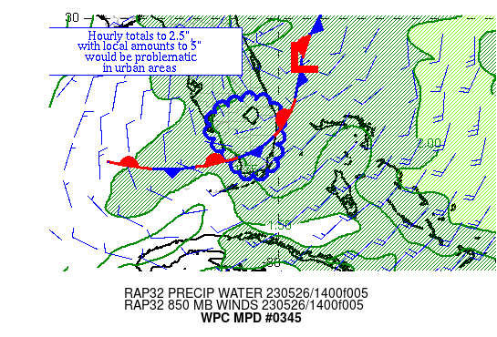
Summary...Thunderstorms with heavy rainfall are beginning to
develop across southern FL.  Hourly rain totals to 2.5" with local
amounts to 5" could cause issues, particularly in urban centers.

Discussion...Showers and thunderstorms are beginning to develop in
the vicinity of a front across the southern peninsula, to the
southwest of a developing low pressure area offshore Cape
Canaveral.  Despite the boundary's location, moisture is plentiful
on both sides.  Precipitable water values are near 1.8" per the
MFL/Sweetwater FL sounding.  Low-level inflow is weak but
cyclonic.  Effective bulk shear, however, is near 25 kts and ML
CAPE is 2000+ J/kg per SPC mesoanalyses.

With the flow more westerly than usual, any sea breeze fronts are
likely to converge near the analyzed frontal position near the
Gold Coast.  The front's reflection at 850 hPa will also be
drifting from west to east across the peninsula with time.
Daytime heating should allow ML CAPE to rise another 1000-1500
J/kg more, which could lead to instantaneous rain rates which
become quite high.  The available ingredients suggest that hourly
rain totals to 2.5" and local amounts to 5" are expected, which
along with higher instantaneous rates would be more of a problem
in urban areas.  With rainfall this past week ranging between
300-600% of average across the peninsula, there may be greater
sensitivity than usual in areas that are not wetlands/swamps.

Roth

ATTN...WFO...KEY...MFL...MLB...TBW...

ATTN...RFC...SERFC...NWC...

LAT...LON   27458103 27348024 26807999 25598010 25228034
            25078094 25178122 25458126 25738146 25838171
            26358205 26858212 27138180
Last Updated: 1205 PM EDT Fri May 26 2023
|


