| WPC Met Watch |
|
|
Mesoscale Precipitation Discussion: #0347 (2021) |
|
(Issued at 648 PM EDT Fri Jun 18 2021
) |
|
| MPD Selection |
|
|
|
|
|

Mesoscale Precipitation Discussion 0347
NWS Weather Prediction Center College Park MD
648 PM EDT Fri Jun 18 2021

Areas affected...Southwest Ohio...Central & Southeast
Indiana...Ext Northern Kentucky...

Concerning...Heavy rainfall...Flash flooding likely

Valid 182245Z - 190445Z

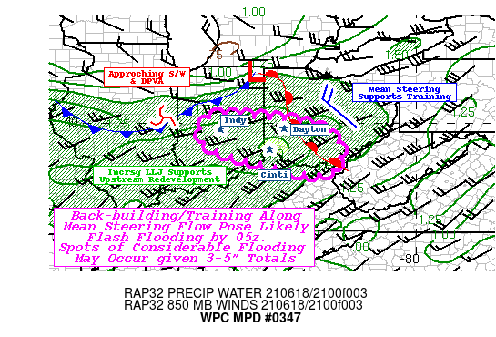
SUMMARY...Expanding convective complex with upstream redevelopment
and training becoming increasingly possible posing flash flooding
risk

DISCUSSION...GOES-E Visible imagery along with regional RADAR
mosaic denote a stronger supercell and few additional developing
cells in the vicinity of a NNW to SSE oriented warm front across
western to south-central Ohio.  Within the warm sector increasing
aggitated strato-cu deck is denoted within very unstable
environment sampled by 20z ILN sounding with 3500+ J/kg of
SBCAPEs.  Surface Tds in the mid 70s with CIRA LPW denoting
enhanced moisture axis across the lower Ohio River from Sfc to 7H
totaling toward 1.75"+.   Flux convergence along the warm front is
steadily increasing with strong orthogonal flow from sfc
(15-20kts) to 85H (30kts) along this moisture axis.   This flow is
expected to maintain/strengthen in the next few hours with the
approach of a compact mid-level shortwave currently crossing the
IL/IND border.  A subtle cold front is dropping southward and may
help to provide some convergence though the DPVA is likely to be
the main player for UVV and upscale enhancement.  Additionally,
propagation vectors will begin to veer toward opposition to the
mean steering flow given strengthening low level flow effectively
reducing Corfidi-vectors to near zero-10kts after 00z.  As such
flanking development will have the potential to train
east-southeastward in the short-term before potentially becoming
stationary.  The 18z NAM-Conest, while typically hot in rainfall
totals, does have an evolution that appears reasonable given the
current trends which highlights the I-74 corridor from
Indianapolis to Cincinnati.

With enhanced moisture entrainment toward 00z, rainfall efficiency
will increase, particularly near rotating updrafts and moisture
profiles will saturate with TPW increasing to near 2".  As such,
hourly rates of 2.5"/hr are possible near supercells with the
average cells along the line around 2"/hr.   This alone is likely
sufficient to exceed lower flash flood guidance (>1.5"/hr) along
the urban I-75 corridor; however, even outside the urban centers
the potential for 3-5" by 04z is likely to pose a flash flooding
risk given 3-6hr FFG value below 3" throughout the MPD area.  The
overall coverage of rainfall capable of flash flooding is expected
to be sizable within the delineated area as well, and flash
flooding may be considerable at one or two isolated locales,
particularly if cells train over one of the urban centers in SW
Ohio.

Gallina

ATTN...WFO...ILN...IND...LMK...RLX...

ATTN...RFC...OHRFC...NWC...

LAT...LON   40218619 40218555 40108433 39888323 39268239
            38418286 38778500 39318658 40008672
Last Updated: 648 PM EDT Fri Jun 18 2021
|


