| WPC Met Watch |
|
|
Mesoscale Precipitation Discussion: #0348 (2023) |
|
(Issued at 542 PM EDT Fri May 26 2023
) |
|
| MPD Selection |
|
|
|
|
|

Mesoscale Precipitation Discussion 0348
NWS Weather Prediction Center College Park MD
542 PM EDT Fri May 26 2023

Areas affected...Portions of the Great Basin

Concerning...Heavy rainfall...Flash flooding likely

Valid 262140Z - 270240Z

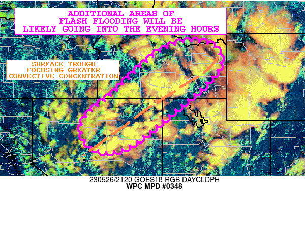
SUMMARY...Additional areas of flash flooding will be likely over
the next several hours from locally slow-moving pockets of heavy
showers and thunderstorms.

DISCUSSION...GOES-W IR and Day Cloud Phase RGB satellite imagery
in conjunction with dual-pol radar shows a rather widespread area
of heavy shower and thunderstorm activity across the Great Basin.
The activity is associated with a broad upper trough along with
embedded slow-moving vort centers in conjunction with strong
surface heating/surface-based instability and orographics.

MLCAPE values are still locally on the order of 500 to 1000 J/kg
and over the last couple of hours, some of the more robust
convective growth has been situation along a southwest to
northeast axis from central NV into southern ID where there is a
well-defined surface trough. This resulting corridor of somewhat
stronger surface convergence and pooling of instability has
already been producing locally concentrated areas of convection
with rainfall rates of 1 to 1.5 inches/hour based on the latest
MRMS data.

The hires CAM guidance has largely been underdone with the
coverage and especially the intensity of the activity. Given the
degree of cloud-top cooling still ongoing and the level of
instability still left over the Great Basin, additional concerns
are expected over the next several hours for locally heavy
rainfall.

Some additional storm total amounts of 2 to 3 inches cannot be
ruled out given the high rainfall rates and slow cell-motions.
Given this and the fact that USGS-based data shows elevated
streamflows, there will be a likelihood for seeing more flash
flooding going into the early evening hours.

Orrison

ATTN...WFO...BOI...LKN...MSO...PIH...REV...SLC...TFX...

ATTN...RFC...CBRFC...CNRFC...MBRFC...NWRFC...NWC...

LAT...LON   44591297 44331161 43161160 40901414 39801560
            39581686 40251765 41151753 42271620 43901448
Last Updated: 542 PM EDT Fri May 26 2023
|


