| WPC Met Watch |
|
|
Mesoscale Precipitation Discussion: #0365 |
|
(Issued at 1017 PM EDT Wed Jun 04 2025
) |
|
| MPD Selection |
|
|
|
|
|

Mesoscale Precipitation Discussion 0365
NWS Weather Prediction Center College Park MD
1017 PM EDT Wed Jun 04 2025

Areas affected...Southeast Texas...

Concerning...Heavy rainfall...Flash flooding possible

Valid 050215Z - 050630Z

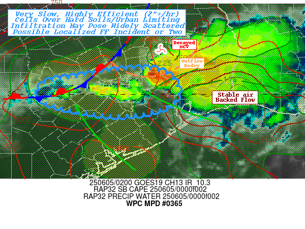
SUMMARY...Slow moving, highly efficient rainfall producing
thunderstorms capable of 2"+/hr and localized totals to 4" pose
flash flooding in urban or along hard drought soil conditions.

DISCUSSION...A decaying MCS continues to drop south along the
northeastern edge of deeper layer ridge across central TX, though
toward a tight gradient of very unstable air to the west and
stabilizing air from the Galveston Bay eastward.  A few cells are
maintaining along the upwind edge entering Montgomery county
toward metro Houston where urban ground conditions and expected
very high rates may result in localized rapid inundation flooding.
 VWP shows some backing of the sfc to boundary layer flow matching
the surface obs off the Upper TX coast.  This should help to
stabilize points east of Montgomery/Harris county. However, 02z
obs still show mid-80s temps over mid to upper-70s Tds and this is
much higher further west where upper 80s remains over similar Tds.
  As the onshore flow continues to back from 130 degrees toward
more 100-115 increasing convergence to the stationary front from
from K5CI to HYI to GYB to LHB, though lesser so to the southward
pushing west to east outflow that the stronger cells of the dying
MCS, suggesting east to westward decay should continue.

Proximity to 2500-3000 J/kg and continued convergence on points
westward toward Bastrop/Fayette county; cells are likely to
maintain/cycle.  Very deep moisture profiles show limited dry air
to convert to cold pools, weak cell motions toward the east along
the eastern edge of the ridge at 5-10kts may also be counteracted
by the onshore flow helping to retrograde the stationary
front/convergence axis.  This should allow for some back-sheared
convective towers.  Recent observations have shown hourly rates of
1.7-2" with some localized totals noted at K11R already over 2.3"
in just over an hour.  Given Total PWat values over 2.25" mainly
below 850mb, rates of 2-2.5"/hr would not be uncharacteristic and
with 30-35kts of effective bulk shear, should be displaced from
the updrafts sufficiently not to completely collapse with one
up/downdraft cycle.

FFG values are very high given drought conditions; however, NASA
SPoRT 0-40cm soil ratios are less than 10% of saturation,
suggesting hard upper layers limiting infiltration similar to
urban conditions near the Houston Metro.  As such, widely
scattered incidents of rapid inundation flooding is considered
possible given high runoff potential with these intense rates.

Gallina

ATTN...WFO...EWX...HGX...

ATTN...RFC...FWR...NWC...

LAT...LON   30559616 30549546 30339507 29979498 29719526
            29569580 29529649 29609713 29859808 30259804
            30399727
Download in GIS format: Shapefile
| KML
Last Updated: 1017 PM EDT Wed Jun 04 2025
|


