| WPC Met Watch |
|
|
Mesoscale Precipitation Discussion: #0369 |
|
(Issued at 241 PM EDT Thu Jun 05 2025
) |
|
| MPD Selection |
|
|
|
|
|

Mesoscale Precipitation Discussion 0369
NWS Weather Prediction Center College Park MD
241 PM EDT Thu Jun 05 2025

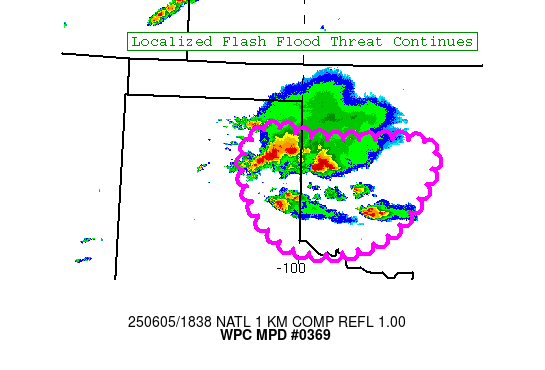
Areas affected...TX Panhandle into Southwest OK

Concerning...Heavy rainfall...Flash flooding possible

Valid 051841Z - 052241Z

Summary...A localized flash flood risk continues across portions
of the Texas Panhandle into southwest Oklahoma.

Discussion...Elevated training convection has resulted in a
localized flash flood risk across portions of the TX Panhandle
early this afternoon. This activity has not been well handled by
any of the high res model guidance. This lowers confidence on
convective evolution over the next few hours. Surface based
instability and PWs are on the increase downstream of the current
convective cluster, suggesting some threat that this activity
maintains into the afternoon hours. Some more discrete cell
development within the inflow of the cluster also suggests the
potential for upscale growth into the afternoon hours. Both
supercell and upwind propagation vectors are off to the southeast,
generally aligned with the orientation of the cluster. Thus the
combination of cell mergers and training suggests that isolated
flash flooding could continue to be a concern along the track of
this convection.

Again confidence is lower than normal on the convective details
over the next few hours. However recent IR satellite trends show
enough persistence of the colder cloud tops to suggest some
continued longevity of this convective cluster. Given the training
orientation and possible cell mergers, a localized flash flood
risk likely continues.

Chenard

ATTN...WFO...AMA...LUB...OUN...

ATTN...RFC...TUA...NWC...

LAT...LON   36110058 35969957 35949789 35479782 34729842
            34419929 34480017 34890067 35620098
Download in GIS format: Shapefile
| KML
Last Updated: 241 PM EDT Thu Jun 05 2025
|


