| WPC Met Watch |
|
|
Mesoscale Precipitation Discussion: #0386 |
|
(Issued at 804 PM EDT Fri Jun 06 2025
) |
|
| MPD Selection |
|
|
|
|
|

Mesoscale Precipitation Discussion 0386
NWS Weather Prediction Center College Park MD
804 PM EDT Fri Jun 06 2025

Areas affected...South-Central High Plains

Concerning...Heavy rainfall...Flash flooding likely

Valid 070002Z - 070602Z

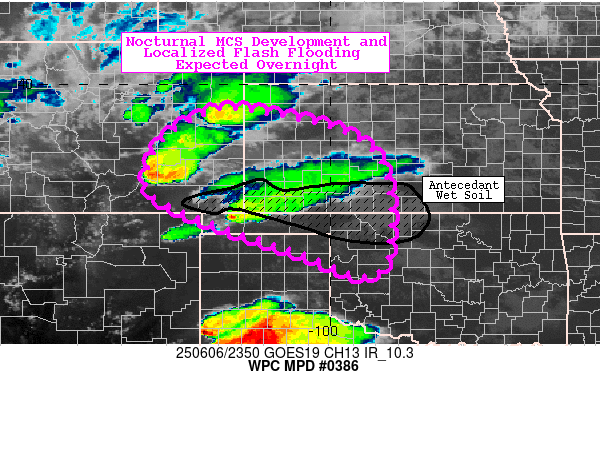
Summary...Scattered supercellular activity over southeast Colorado
into the Oklahoma Panhandle is expected to develop into a
mesoscale convective system (MCS) rest of this evening and track
southeast overnight. The flash flood threat will increase with
this development, particularly as it crosses areas in southern
Kansas which saw heavy thunderstorms last night. Localized flash
flooding is likely through 06Z.

Discussion...Supercells in southeastern CO have developed in a
high shear (60kt 0-6km Bulk Shear)/moderate instability (1500-2000
K/kg SBCAPE) environment. Further development between the two main
cells just prior to 00Z is an indication of the expected MCS
development tonight. The right side of this developing MCS will
cross areas impacted by heavy rain this afternoon from a cell
currently in the OK Panhandle and activity from last night over
southern KS.

Ample moisture is present in CO downstream of this activity with
PW around 1". Further moisture will be provided as it moves into
KS from the nocturnal low-level jet which the development should
turn south into in spite of deep layer westerly flow in an overall
zonal flow pattern over the central U.S. Heavy rainfall is
expected with 1-2" hourly totals, and particularly where flanking
axes become repetitive. Antecedent wet soils are present over
southern KS and far southeast CO where heavy rain has fallen over
the past day.

Jackson

ATTN...WFO...ABQ...AMA...BOU...DDC...GLD...OUN...PUB...

ATTN...RFC...KRF...TUA...NWC...

LAT...LON   39400205 38889968 37839869 35609888 36120083
            37030343 37650430 38700390 39310290
Download in GIS format: Shapefile
| KML
Last Updated: 804 PM EDT Fri Jun 06 2025
|


