| WPC Met Watch |
|
|
Mesoscale Precipitation Discussion: #0389 |
|
(Issued at 135 AM EDT Sat Jun 07 2025
) |
|
| MPD Selection |
|
|
|
|
|

Mesoscale Precipitation Discussion 0389
NWS Weather Prediction Center College Park MD
135 AM EDT Sat Jun 07 2025

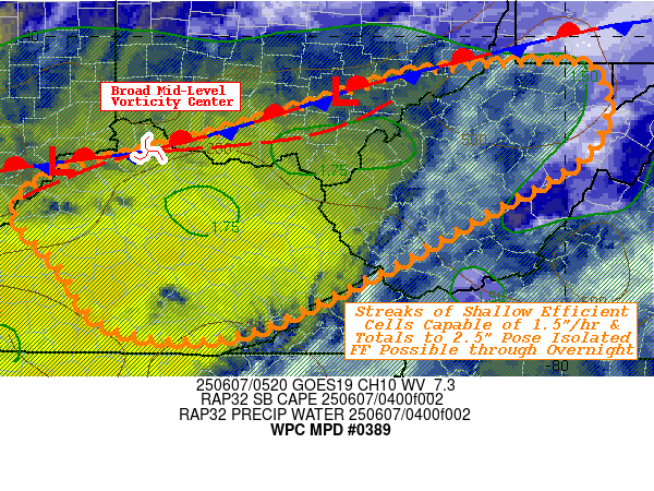
Areas affected...Southern OH...Central to Northeast KY...Much of
WV...

Concerning...Heavy rainfall...Flash flooding possible

Valid 070535Z - 071100Z

SUMMARY...Shallow but efficient slow moving cells capable of
1.5"/hr with some potential repeating may result in widely
scattered localized flash flooding conditions overnight.

DISCUSSION...GOES-E WV suite depicts a broad west to east
shortwave feature crossing near Cincinnati, OH with favorable
vorticity advection supporting a weak surface to boundary layer
wave in southeast OH along/south of a stagnant stationary front.
Ample low level moisture in the mid to upper 60s and spots of low
70s, while CIRA LPW shows a ribbon of enhanced moisture
along/ahead of this wave bringing nearly moist/saturated profiles
to support 1.75" total PWats.  Some weak remaining unstable air
remains with 250-500 J/kg of SBCAPE in the vicinity of the Ohio
River and southward into eastern KY.   As such, RADAR and 10.3um
IR loop shows a few very shallow cells along of the wave in S OH
as well as back in the trailing trof of the mid-level wave
along/east of Louisville, KY.

While weak, there are pockets of enhanced moisture convergence in
the 10-15kts of veered low level flow to tap the weak instability.
 With the shallow updrafts, all of it are within the warm cloud
layer, will result in highly efficient tropical like showers.
Rates of 1.5-1.75" could be common over highly focused fairly
narrow updrafts.   The concern is the overall deep layer steering
is unidirectional nearly west to east which also will contribute
to an upslope component across E KY/WV over the next few hours.
As such, narrow streaks of hour or two of training may support
localized streaks of  1.5-2.5" over 1-3hrs across the area of
concern.  Given complexity of terrain, recent above average
rainfall over S OH, N WV and soil saturation ratios in the 60-70%
and isolated incident or two of flash flooding will continue to be
possible through the overnight period.

Gallina

ATTN...WFO...ILN...JKL...LMK...PBZ...RLX...

ATTN...RFC...TIR...NWC...

LAT...LON   39707997 39537964 39197955 38677987 38038101
            37448208 36808358 36908489 37528538 38118588
            38538544 38698469 38838412 38988358 39258270
            39598157
Download in GIS format: Shapefile
| KML
Last Updated: 135 AM EDT Sat Jun 07 2025
|


