| WPC Met Watch |
|
|
Mesoscale Precipitation Discussion: #0389 (2021) |
|
(Issued at 1203 PM EDT Sat Jun 26 2021
) |
|
| MPD Selection |
|
|
|
|
|

Mesoscale Precipitation Discussion 0389
NWS Weather Prediction Center College Park MD
1203 PM EDT Sat Jun 26 2021

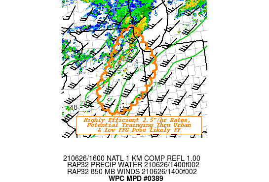
Areas affected...Central to Northeast IL...Ext Northwest IND...

Concerning...Heavy rainfall...Flash flooding possible

Valid 261600Z - 262100Z

SUMMARY...Highly efficient, potentially training thunderstorms
crossing saturated grounds and urban Chicagoland pose likely flash
flooding through early afternoon.

DISCUSSION...GOES-E WV suite depicts peak shortwave ridging across
SE WI into Lower Lake Michigan with approach of shortwave across E
IA.  As such, a low level inflection/effective triple-point will
pivot across S WI and maintain the main deep layer moisture
transport across the area of concern through the early afternoon
hours.  12z RAOB at ILX depicts this deep moisture with only a
small layer of dry air in the 8-65H layer though RH values are
well above 70% and with a very high 15Kft FGZ layer suggesting
fairly deep warm cloud processes for solid rainfall efficiency.
There is solid 1000+ CAPE at 12z, but breaks in the clouds
particularly east of I-51 have supporting increasing values
nearing 1750 J/kg (surface-based).  With limited capping noted,
convection is already initiating from NW Chicagoland toward
central IL.

Total PWat values over 1.9" and strong 35-40kts of upstream flux
entrainment should support high rainfall efficiency with rates
over 2.5"+/hr.  The limiting factor will be duration due to fairly
strong low level steering flow at 35-40kts through 850-5H,
limiting some duration.  Though given the unidirectional flow and
upstream DPVA and clearing skies, further development is expected.
  Given the limited capping, the cores are not likely to be
large/broad but numerous enough to support some cross tracks or
training.  Very slow eastward propagation could allow for spot
totals over 3" to occur.

Recent heavy rainfall per AHPS anomalies and NASA SPoRT LIS
0-40cm, and NWM soil saturation ratios suggest the low FFG values
in the area (generally less than 1.5"/1hr and 2"/3hr) with some
highly localized extremely low values (less than .5") suggest even
quick sub-hourly totals of 1" are likely to induce scattered flash
flooding conditions.  Max totals in some of the 12z Hi-Res Cams
suggest 4" are possible but are almost idealized with maximum
training conditions, so if this occurs through most compromised
area or urban Chicago...isolated considerable flash flooding may
occur by 21z.

Gallina

ATTN...WFO...ILX...LOT...

ATTN...RFC...NCRFC...OHRFC...NWC...

LAT...LON   42448770 42098761 41768741 41548719 40868723
            39888837 39928935 40618950 41288892 41498881
            42318819
Last Updated: 1203 PM EDT Sat Jun 26 2021
|


