| WPC Met Watch |
|
|
Mesoscale Precipitation Discussion: #0397 |
|
(Issued at 246 AM EDT Sun Jun 08 2025
) |
|
| MPD Selection |
|
|
|
|
|

Mesoscale Precipitation Discussion 0397
NWS Weather Prediction Center College Park MD
246 AM EDT Sun Jun 08 2025

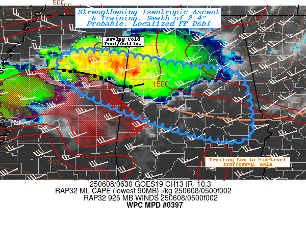
Areas affected...Central AL...East-central MS...

Concerning...Heavy rainfall...Flash flooding possible

Valid 080645Z - 081200Z

SUMMARY...Expanding convective complex with favorable
repeating/training elements suggest localized 2-4" totals and
localized flash flooding is increasingly possible through early
morning.

DISCUSSION...GOES-E 10.3um EIR loops shows individual
cells/overshooting tops continue to cool and expand westward along
the flanking line. Cooling tops to -65 to -70C have expanded
westward generally aligned with the collapse of the upstream cells
in SE AR.  06z surface analysis along with VWP, suggests increased
southwesterly flow from surface to boundary layer combined with
forward flank cold pool is resulting in a more orthogonal ascent
plane for convective expansion.  GOES-WV and EIR also denotes a
trailing boundary from exiting shortwave/mid-level trough can be
seen extending across the Fall-line in SC across central GA before
angling back northwest.  SWIR and RADAR shows some downstream TCu
developing along this axis; which also seems to align ideally from
NW to SE with propagation vectors.

RAP analysis shows a pool of uncapped 2000-2500 J/kg MLCAPE within
the best streamlines into the expanding complex.   Tds in the mid
to upper 70s combined with a pool of 700mb enhanced moisture is
resulting in localized PWats of 1.8 to 2", all adding into
continued potential for 2-2.5"/hr rates.  Expanding NW line should
allow for longer duration of 2-3 hours, suggesting a swath of 2-4"
is becoming more probable.  Boundary layer inflow is currently
peaking around 20-30kts, but is expected to diminish slowly toward
12z, likely reducing convective strength as the complex rolls
through central AL.

Hydrologically, this complex as it tracks east-southeast is moving
into an area of reduced FFG values with 1hr values of 2-3" (less
than 2" near cities like Birmingham) and 3hr values are generally
around 3-3.5".   As such, places of ideal, greatest prolonged
training are well within the possibility of exceedance and
therefore, flash flooding is considered possible through 12z.

Gallina

ATTN...WFO...BMX...JAN...MEG...

ATTN...RFC...ALR...ORN...NWC...

LAT...LON   34138859 33838705 33628573 32838543 32168556
            32338687 33068884 33658972 34098956
Download in GIS format: Shapefile
| KML
Last Updated: 246 AM EDT Sun Jun 08 2025
|


