| WPC Met Watch |
|
|
Mesoscale Precipitation Discussion: #0402 |
|
(Issued at 1211 PM EDT Sun Jun 08 2025
) |
|
| MPD Selection |
|
|
|
|
|

Mesoscale Precipitation Discussion 0402
NWS Weather Prediction Center College Park MD
1211 PM EDT Sun Jun 08 2025

Areas affected...Portions of the Central Appalachians and Northern
Mid-Atlantic

Concerning...Heavy rainfall...Flash flooding likely

Valid 081610Z - 082210Z

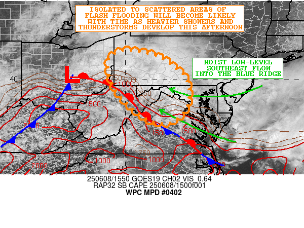
SUMMARY...Areas of moderate to heavy rainfall will continue
through this afternoon with an expectation that scattered
thunderstorms will develop and produce heavier rates. Given the
moist and sensitive antecedent conditions, the additional rainfall
is likely to result in some runoff problems and flash flooding.

DISCUSSION...The midday GOES-E visible satellite imagery along
with regional radar data shows areas of moderate to locally heavy
rain falling over portions of western and southwest PA down
through the MD/WV Panhandles and into northern VA. This rainfall
is being driven by the arrival of a shortwave trough from the OH
Valley which is promoting a northwest to southeast corridor of
isentropic ascent and frontogenetical forcing along and just
poleward of a warm front lifting gradually northeastward into the
region.

Meanwhile, solar insolation is seen taking place farther west
across central and northern WV and western VA which is allowing
for some CU/TCU development over the higher terrain. Surface-based
instability is expected to continue to increase going through the
afternoon hours, and with convergent flow along the front and
orographic forcing over the higher terrain, there should be the
development and gradual expansion of some heavier shower and
thunderstorm activity over the next few hours. It should be noted
that moist low-level southeast flow is expected to become better
established into the Blue Ridge this afternoon as well, and this
may yield some locally more concentrated areas of convection in
these areas.

The environment is pretty moist and the 12Z RAOBs at KPIT and KIAD
showed 1.42 inch and 1.62 inch PWs respectfully which are at or
just above the 90th percentile of daily climatology. This overall
environment should favor at least above average rainfall
efficiency across the region and especially with some of the
forcing that will be occurring this afternoon in the warm layer of
the column.

Rainfall rates with the instability driven convective elements
this afternoon from southwest PA down through northern VA will
likely be quite high and capable of reaching 1.5 to 2 inches/hour.
The 12Z CAM guidance suggests that some localized rainfall totals
by this evening may reach as high as 2 to 3+ inches where some of
the slower moving cells evolve.

Given the wet antecedent conditions and high rainfall rates,
isolated to scattered areas of flash flooding are likely.

Orrison

ATTN...WFO...AKQ...CLE...CTP...LWX...PBZ...RLX...

ATTN...RFC...RHA...TIR...NWC...

LAT...LON   41317974 41117866 40677788 39957717 38757715
            38037794 38227904 39408035 40708079 41228041
Download in GIS format: Shapefile
| KML
Last Updated: 1211 PM EDT Sun Jun 08 2025
|


