| WPC Met Watch |
|
|
Mesoscale Precipitation Discussion: #0404 |
|
(Issued at 630 PM EDT Sun Jun 08 2025
) |
|
| MPD Selection |
|
|
|
|
|

Mesoscale Precipitation Discussion 0404
NWS Weather Prediction Center College Park MD
630 PM EDT Sun Jun 08 2025

Areas affected...southwestern PA into northern and eastern WV,
northern VA, western MD, and DC

Concerning...Heavy rainfall...Flash flooding likely

Valid 082230Z - 090400Z

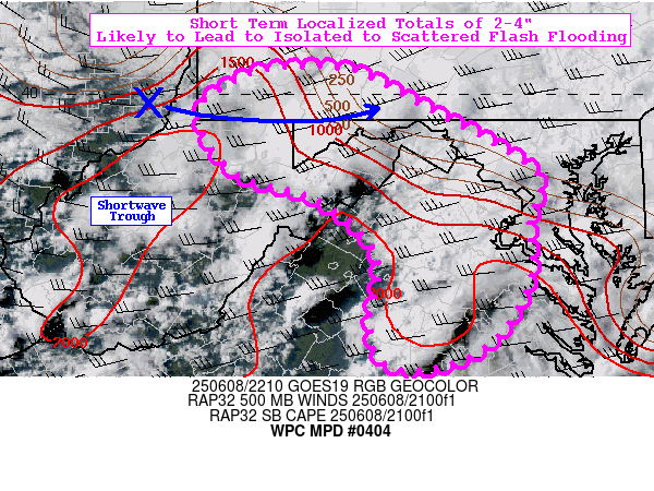
Summary...Short term localized totals of 2-4" likely to lead to
isolated to scattered instances of flash flooding.

Discussion...Showers and thunderstorms have been increasing in
coverage over the past few hours in the vicinity of a warm front
draped from southwestern PA through western MD, the WV Panhandle,
northern VA. A shortwave trough will pivot through the area over
the next several hours, providing additional lift via DPVA. The
mesoscale environment is characterized by a SBCAPE gradient of
500-2000 J/kg, precipitable water (PW) values of 1.4-1.7 inches
(near the 90th percentile, per IAD sounding climatology), and
effective bulk shear of 30-45 kts. MRMS estimates hourly rainfall
totals as high as 1-2" in association with WSW-to-ENE training
elements in the most intense multi-cell clusters, but fairly
progressive storm motions (averaging near 20 kts) with more
semi-discrete cells has tended to limit localized totals to 1".

Going forward, there could be more substantial organization of
convection going into the early evening hours given the overall
favorable environment for heavy rainfall. The area of greatest
concern in the near term is along the Blue Ridge Mountains from
the eastern tip of WV southward to Shenandoah NP, as well as
eastward into the DMV region. While hi-res models are not in the
best agreement (with the HRRR in particular really struggling to
properly initialize the the convection that is already ongoing),
the best signal for heavy rainfall is located in this area (with
fairly good agreement between the 18z HREF PMM and experimental
12z REFS PMM, suggesting localized 2-3" totals). There was also a
distinct uptick in the 18z HREF 40-km neighborhood 3" exceedance
probabilities (largely due to the addition of the 18z NAM-nest),
which indicate 30-50% odds for localized 3" exceedance (through
03z). Given 3-hr FFG as low as 1.0-1.5" (mainly across northern
sections of the MPD, including the aforementioned area of
concern), isolated to scattered instances of flash flooding are
likely. Convection should decrease substantially in coverage by
03-04z with waning instability and increasing convective
inhibition.

Churchill

ATTN...WFO...AKQ...CTP...LWX...PBZ...RLX...RNK...

ATTN...RFC...ALR...RHA...TIR...NWC...

LAT...LON   40287932 40237883 39887815 39487738 39107685
            38617697 38007695 37317740 37047812 37157854
            37567865 38277858 38867921 39168012 39768049
            40098017 40247979
Download in GIS format: Shapefile
| KML
Last Updated: 631 PM EDT Sun Jun 08 2025
|


