| WPC Met Watch |
|
|
Mesoscale Precipitation Discussion: #0406 (2020) |
|
(Issued at 659 AM EDT Tue Jun 30 2020
) |
|
| MPD Selection |
|
|
|
|
|

Mesoscale Precipitation Discussion 0406
NWS Weather Prediction Center College Park MD
659 AM EDT Tue Jun 30 2020

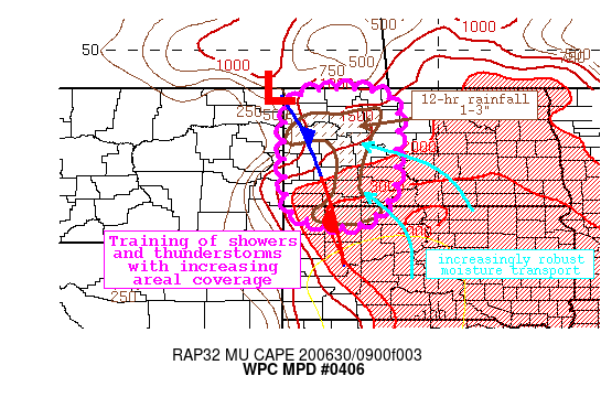
Areas affected...Western North Dakota

Concerning...Heavy rainfall...Flash flooding possible

Valid 301058Z - 301600Z

Summary...Showers and thunderstorms developing this morning along
a stalled boundary will gradually increase in coverage and
intensity. Rainfall rates at times will exceed 1"/hr, and training
of cells to the north could produce locally 2-3". Flash flooding
is possible.

Discussion...GOES-16 IR imagery this morning shows an expansive
area of cloud tops of less than -60C across northern SD, western
ND, and into eastern MT. The coldest tops are spiking below -70C,
associated with intensifying and regenerating convection across
far NW SD evident as well on the regional radar mosaic. SW of this
cluster, a closed low is spinning across northern UT/eastern ID,
with a clear diffluence signature evident of a jet streak racing
northward into Canada. At the surface, a wave of low pressure was
positioned near the MT/ND/Canada intersection, with a stationary
boundary extending southeastward from there. Recent GPS TPW
observations indicated that PWs were above 1.5" east of the front,
with a pool of extreme instability to the south noted by RAP
MUCape of >4000 J/kg.

As the morning progresses, strong WAA through a 40kt 850mb LLJ
will persist from the SE. Along the nose of this LLJ, confluence
and isentropic ascent atop the effective low/mid level front will
drive regeneration of convective cells across far NW SD and into
southern ND. With time, this intense warm advection should erode
any cold pool surface CIN and drive the best activity northward as
the LLJ begins to impinge upon the true surface front. During this
time, PWs are progged to surge towards 1.75", approaching 3
standard deviations above the climo mean, while the pool of >4000
J/kg MUCape extends as a ribbon northward into ND. Additionally,
the aforementioned closed low will pivot eastward driving the
trough towards a negative tilt, further enhancing synoptic ascent
already provided via mid-level impulses and continuous ventilation
within the RRQ of the jet streak.

While the best overlap of forcing and thermodynamics is expected
this afternoon, and will almost certainly necessitate a subsequent
MPD, an evolving flash flood threat is developing this morning as
well. As the thunderstorms develop and lift northward, they will
gradually intensify with rain rates rising to above 1"/hr, which
is at or above much of the regional FFG. Storms are likely to
train to the north along the front, so despite storm motions
increasing to 20-25 kts, training of the intense echoes could
produce 2-3" of rainfall through late morning. Some of this area
received MRMS estimated rainfall of 1-3" with locally up to 4" in
the last 12 hours, so soils are already saturated, and the NWM
shows an increasing coverage of high stream flow anomalies. Flash
flooding is possible, with the threat shifting northward and
increasing into the afternoon.

Weiss

ATTN...WFO...ABR...BIS...UNR...

ATTN...RFC...MBRFC...NCRFC...NWC...

LAT...LON   48980261 48970214 48880162 48760130 48480107
            48100107 47590111 47150110 46790113 46510113
            46200124 45950145 45700166 45550189 45490225
            45490266 45530314 45650360 45910386 46480396
            47540398 47820401 48100394 48170402 48500389
            48800360 48920324 48960281
Last Updated: 659 AM EDT Tue Jun 30 2020
|


