| WPC Met Watch |
|
|
Mesoscale Precipitation Discussion: #0406 |
|
(Issued at 1117 PM EDT Sun Jun 08 2025
) |
|
| MPD Selection |
|
|
|
|
|

Mesoscale Precipitation Discussion 0406
NWS Weather Prediction Center College Park MD
1117 PM EDT Sun Jun 08 2025

Areas affected...South-central to Southeast Virginia...

Concerning...Heavy rainfall...Flash flooding possible

Valid 090315Z - 090700Z

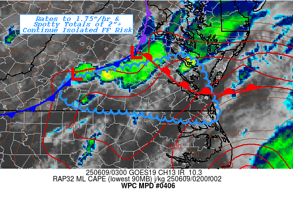
SUMMARY...Continued limited flash flooding risk continues for a
few more hours as remaining training cells approach southeast VA
and more susceptible urban environment.

DISCUSSION...GOES-E 10.3um and RADAR mosaic across the
Mid-Atlantic shows a slowly stabilizing environment, particularly
northward along the advancing occluded front from HGR/FDK MD into
north-central VA toward the triple point near LKU.  The warm front
remains well defined cross the lower neck into Hampton Roads and
out into the Atlantic through the mouth of the Chesapeake Bay.
RAP analysis shows a well of 1000-1500 J/kg of MLCAPE along and
east of the slowly advancing cold front out near the slopes of the
Blue Ridge across south-central VA into southeast VA.  However,
VWP shows mid to upper level trof is starting to slide away
further northeast but 850mb winds remain mildly convergence as
down-sloping becomes more westerly and into the 20-25kt range.  As
such, a few convective cells remain across south-central VA and
while there are some indications of cold pool/outflow, there is
some upstream redevelopment on that low level convergence to keep
activity going.   Deep layer flow remains a bit north of ideally
parallel to the orientation of the ongoing convection but still
remains suggestive of training/repeat component as the cells
continue to drift east.

Total moisture of 1.75" and deep warm layer and flux for rainfall
production helps to maintain solid efficiency for 1.5-1.75"/hr
rates with length of training to support 1-2 hour duration for
additional 1.5-3" totals over the next few hours.  This is a the
lower threshold of FFG values in the rural areas, however, if
cells can maintain strength and tap remaining instability pockets,
these rates/totals would pose a greater potentail for flash
flooding across the urban locations from Richmond/Petersburg
southeastward toward Norfolk and Hampton Roads.  So while not the
highest confidence it will given the stabilizing environment with
loss of heating...the risk is sufficient for localized flash
flooding to continue to be possible for the next few hours.

Gallina

ATTN...WFO...AKQ...RNK...

ATTN...RFC...ALR...RHA...NWC...

LAT...LON   37857671 37637628 37077605 36847595 36567584
            36327595 36397697 36557779 36587861 36767934
            37157952 37427867 37637752 37747708
Download in GIS format: Shapefile
| KML
Last Updated: 1117 PM EDT Sun Jun 08 2025
|


