| WPC Met Watch |
|
|
Mesoscale Precipitation Discussion: #0408 |
|
(Issued at 121 AM EDT Mon Jun 09 2025
) |
|
| MPD Selection |
|
|
|
|
|

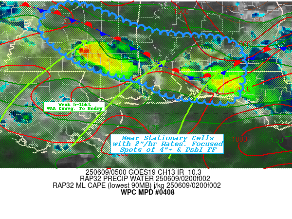
Mesoscale Precipitation Discussion 0408
NWS Weather Prediction Center College Park MD
121 AM EDT Mon Jun 09 2025

Areas affected...Southern MS...Southern AL...Far Western FL
Panhandle...

Concerning...Heavy rainfall...Flash flooding possible

Valid 090520Z - 091030Z

SUMMARY...Stationary/slow moving clusters along old outflow
boundary/theta-E gradient pose highly focused totals to 4"+ and
possible widely scattered rapid inundation flooding overnight.

DISCUSSION...04z Surface and RAP analysis shows a solid theta-E
gradient across southern GA, southeast AL before dipping near
Pensacola, FL before angling northwest into south-central MS with
about 4-8 degrees making it subtle.  However, total PWat analysis
shows the feature much better with long strung out axis of 2"+
total PWats seen well at the 850-500mb layers in CIRA LPW.
Recent uptick in southwesterly surface to 850mb flow at 5-15kts
results in sufficient isentropic ascent in small clusters (near
the angle in far W FL) and utilizing the slightly uncapped 2000
J/kg MLCAPE along the boundary.   Upper level flow is generally
weak, but with the approach of the stronger upper-level jet
upstream in the Plains, is providing some deeper layer effective
bulk shear into the 20-30kt range to provide some organization to
the convective clusters to keep the downdrafts from collapsing in
on the clustered updrafts.  Given total PWats of 2" and sufficient
15kt flux, rates of 2-2.5" have been seen in these clusters.
Currently the line is still upstream enough that 500-1000
thickness weak and therefore, upstream inflow is about equal to
easterly steering flow to keep cells fairly stationary to weakly
moving.  New updrafts along weak outflow helps to expand the
clusters (particularly further west into south-central MS), so
isolated totals of 3-5" are becoming increasingly possible
resulting in focused possible rapid inundation flooding.

As the upstream MCS continues to barrel through eastern Texas, low
level inflow will back a bit and WAA should expand convective
initiation southern to west-central MS.  This increase in inflow
is also likely to increase forward cell motions toward the north
likely reducing overall totals but increasing coverage of 1-3"
totals in advance of the line.  Will have to continue to monitor
the area into the dawn time frame for subsequent MPDs.

Gallina

ATTN...WFO...JAN...MOB...TAE...

ATTN...RFC...ALR...ORN...NWC...

LAT...LON   32608994 31938809 31768645 31388595 30698598
            30298622 30338699 30488782 30788833 31068944
            31559031 32149076
Download in GIS format: Shapefile
| KML
Last Updated: 121 AM EDT Mon Jun 09 2025
|


