| WPC Met Watch |
|
|
Mesoscale Precipitation Discussion: #0416 |
|
(Issued at 1137 PM EDT Mon Jun 09 2025
) |
|
| MPD Selection |
|
|
|
|
|

Mesoscale Precipitation Discussion 0416
NWS Weather Prediction Center College Park MD
1137 PM EDT Mon Jun 09 2025

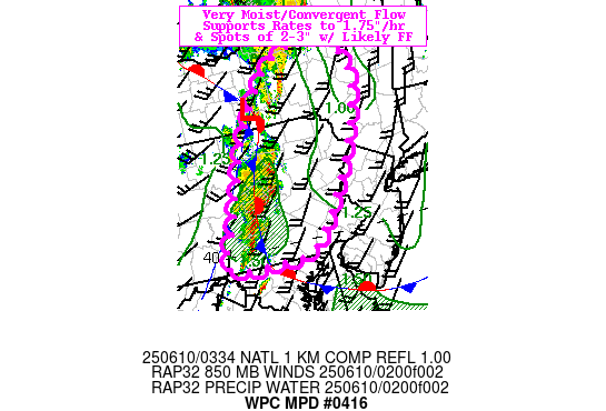
Areas affected...Eastern PA...South-Central NY...

Concerning...Heavy rainfall...Flash flooding likely

Valid 100335Z - 100900Z

SUMMARY...Strong, efficient rainfall producing line of
thunderstorms likely to continue flash flooding risk in complex
terrain with spots of 2-3" probable.

DISCUSSION...CIRA LPW along with RAP and surface analysis shows a
pocket/narrow wedge of surface to 850mb moisture lifting north
through N MD into south-central MD with overall totals reaching
over 1.5" through full depth.  The wedged stationary front that
has been banked up through east-central PA has seen some
sharpening as the cold air damning region over the
Poconos/Catskills has seen a low level wind shift from the
southeast further increasing moisture convergence as the
initial/leading edge of the effective leading cold front maintains
about a 20-45 degrees of convergence at the western edge of the
warm conveyor belt/wedge of enhanced moisture.   This higher,
untapped unstable air continues to run about 500-750 J/kg with
MUCAPE through the narrowing warm sector still about 250 J/kg into
south-central NY.

Aloft, the split in the upper-level jet/maximum diffluence
continues to provide solid outflow in both directions and
maintaining updraft strength though the eastern branch arch can be
seen crossing the Potomac River just upstream which has been
limited the upstream convective environment a bit more to allow
for continued inflow across south-central PA.  Additionally, as
the base of the leading shortwave continues to peel northward
across Lake Ontario, the trailing DPVA is providing a secondary
push of convergence across north-central PA with new sprouting
development in Tioga county lifting northward, so while
instability is reducing, there is sufficient dynamics to maintain
a risk of slowing eastward propagation cells across south-central
NY near the surface wave/intersection of the lead/dying cold front
at the peak of the warm conveyor belt.

Throughout the line with total PWats to 1.5", 20-30kts of low
level, strong convergent/confluent flow should continue to support
stronger cells capable of efficient warm cloud processes and rates
of 1.5" occasionally reaching 1.75"+/hr.   Oblique cell motion
toward the NNE and density of convective cores will allow for
scattered training/repeating elements to increase over 1-2hrs for
spots of 2-3" totals. Given complex terrain/naturally lower FFG
values, incidents of flash flooding are likely to continue into
eastern PA with the Poconos/Catskills at naturally higher risk for
rapid flows in narrow channels/gullies.

Gallina

ATTN...WFO...ALY...BGM...CTP...PHI...

ATTN...RFC...RHA...TAR...NWC...

LAT...LON   43117482 42607439 41847461 40887516 40117576
            39797614 39737660 39807792 40647760 42117689
            43097588
Download in GIS format: Shapefile
| KML
Last Updated: 1137 PM EDT Mon Jun 09 2025
|


