| WPC Met Watch |
|
|
Mesoscale Precipitation Discussion: #0421 |
|
(Issued at 534 PM EDT Wed Jun 11 2025
) |
|
| MPD Selection |
|
|
|
|
|

Mesoscale Precipitation Discussion 0421
NWS Weather Prediction Center College Park MD
534 PM EDT Wed Jun 11 2025

Areas affected...central TX

Concerning...Heavy rainfall...Flash flooding likely

Valid 112131Z - 120315Z

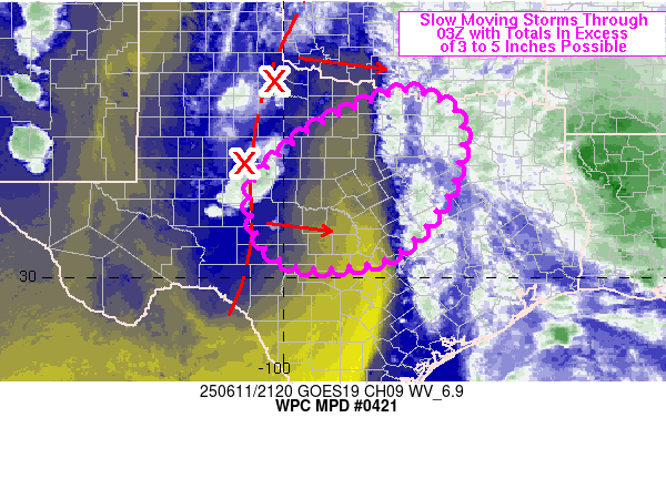
Summary...Slow moving storms atop portions of saturated soils are
expected to produce locally heavy rain in excess of 3-5 inches
over the next 3-6 hours for portions of central TX. Localized to
scattered flash flooding is expected to result.

Discussion...Water vapor imagery from GOES East showed a
south-north elongated mid to upper-level low over west-central TX
at 2115Z, slowly edging eastward. One of the embedded vorticity
maxima was located halfway between BPG and ABI and a small cluster
of slow moving thunderstorms has developed to its south and east.
A general decrease in low to mid-level cloud cover since 17Z has
helped with surface heating to the west of a broader shield of
cloud cover over eastern TX. SPC mesoanalysis data from 21Z showed
MLCAPE of 500-1500 J/kg over western and central TX with patchy
but decreasing CIN along and west of I-35.

RAP forecasts show the mid to upper-level trough and embedded
vorticity maxima will slowly translate eastward over the next
several hours. Additional convective development is likely over
west-central TX in the short term, and over northern portions of
the Edwards Plateau into portions of the I-35 corridor south of
Forth Worth beyond sunset. While PWs are not as high as those over
east TX, they are still about 1.5 to 2.0 inches (via SPC
mesoanalysis) and slow cell movement of 10 kt or less beneath the
upper low will promote locally high rainfall rates of 1-3 in/hr.

Heavy rain over the past 72 hours has increased soil moisture and
reduced FFG to less than 2.5 inches in 3 hours for many locations.
While the coverage of slow moving rain rates should remain
localized to scattered (at best), a fairly broad region of central
TX will be under threat of localized flash flooding with 2 to
3-hour totals of 3 to 5 inches possible through 03Z.

Otto

ATTN...WFO...EWX...FWD...OUN...SJT...

ATTN...RFC...FWR...TUA...NWC...

LAT...LON   33939736 33759676 33419632 32749625 31639662
            30459774 30219949 30620036 31230061 31620069
            32140051 33099941 33669825 33829780
Download in GIS format: Shapefile
| KML
Last Updated: 534 PM EDT Wed Jun 11 2025
|


