| WPC Met Watch |
|
|
Mesoscale Precipitation Discussion: #0425 (2024) |
|
(Issued at 625 PM EDT Tue Jun 11 2024
) |
|
| MPD Selection |
|
|
|
|
|

Mesoscale Precipitation Discussion 0425
NWS Weather Prediction Center College Park MD
625 PM EDT Tue Jun 11 2024

Areas affected...West-Central FL

Concerning...Heavy rainfall...Flash flooding likely

Valid 112224Z - 120224Z

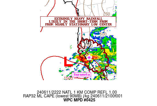
SUMMARY...Extremely heavy rainfall associated a nearly stationary
low center just southwest of Tampa Bay is expected to pose a
short-term urban flash flood threat from Bradenton down to
Sarasota.

DISCUSSION...Late-day GOES-E visible satellite imagery along with
dual-pol radar shows a nearly stationary low center southwest of
Tampa Bay over the far eastern Gulf of Mexico. Rather strong
moisture convergence focused in around the southeast flank of the
low center along with a moderately unstable airmass with MLCAPE
values of 1500 to 2000 J/kg has been resulting in a persistent and
concentrated band of very strong convection with extremely heavy
rainfall rates.

The cloud top temperatures with the convection have been as cold
as -70 to -75C, and with a highly tropical environment with PWs
pushing 2.25+ inches, some of the rainfall rates have been
reaching 3 to 4 inches/hour over the last hour. Part of the
convective band is offshore, but part of it over the last hour has
edged onshore and is impacting the urban corridor from near
Bradenton southward down through Sarasota.

Recent radar trends suggest some northward advance of the
convective band with the low center also showing some evidence of
deepening somewhat which suggests the ongoing convective
organization, albeit it sheared, over the southeast part of the
low center may maintain itself in response to stronger low-level
convergence/forcing.

This suggests at least in the near-term that extremely heavy
rainfall rates within this convective band may continue to edge
farther inland and persist, with impacts in particular along the
Bradenton to Sarosota urban corridor.

Given extremely high rainfall rates of 3 to 4 inches/hour, some
storm totals over the next 2 to 3 hours may locally approach or
exceed 6 to 8 inches. Urban flash flooding is considered likely
given the set-up, and this situation will need to be closely
monitored going into the evening hours.

Orrison

ATTN...WFO...TBW...

ATTN...RFC...SERFC...NWC...

LAT...LON   27928261 27718218 27388201 27078202 26988235
            27258266 27718280
Download in GIS format: Shapefile
| KML
Last Updated: 625 PM EDT Tue Jun 11 2024
|


