| WPC Met Watch |
|
|
Mesoscale Precipitation Discussion: #0431 |
|
(Issued at 555 AM EDT Sat Jun 14 2025
) |
|
| MPD Selection |
|
|
|
|
|

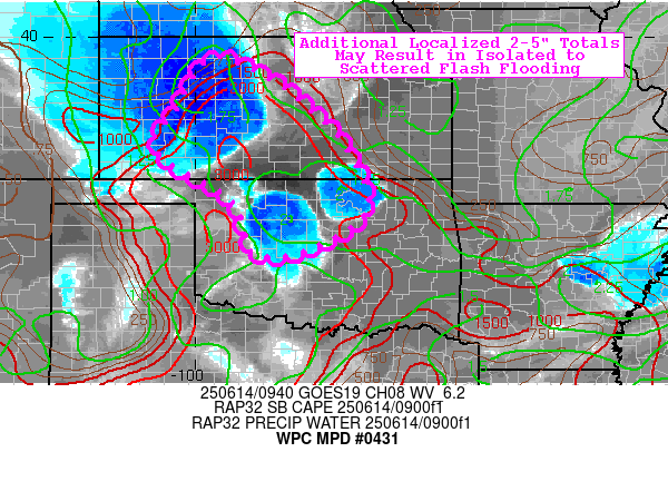
Mesoscale Precipitation Discussion 0431
NWS Weather Prediction Center College Park MD
555 AM EDT Sat Jun 14 2025

Areas affected...south-central KS into north-central OK

Concerning...Heavy rainfall...Flash flooding possible

Valid 140955Z - 141500Z

Summary...Additional localized totals of 2-5" may result in
isolated to scattered flash flooding through mid-morning.

Discussion...A maturing MCS is forward propagating
south-southeastward across portions of eastern KS this morning,
producing hourly totals as high as 2.0-2.5" (with the help of
convective initiation out ahead of the system). Farther south into
north-central OK, convection has managed to initiate within a
moderately capped environment (CIN 75-150 J/kg) due to weak
moisture convergence along a quasi-stationary front. These storms
are nearly stationary within weak steering flow, producing
impressive localized hourly totals of up to 2-3". The mesoscale
environment downstream of the MCS and in the vicinity of the OK
storms is characterized by SBCAPE of 2000-3000 J/kg, precipitable
water values of 1.6-1.8" (above the 90th percentile and near the
max moving average, per OUN sounding climatology), and effective
bulk shear of 15-20 kts.

Although shear should be a somewhat limiting factor for storm
organization, the mature MCS and associated MCV will likely
continue to be sufficient forcing for continued longevity, given
observational trends (despite MCS maintenance values of only
20-40%, largely owing to the lack of shear and deep layer mean
flow). CAMs are somewhat supportive of additional rainfall (while
largely struggling with the OK convective initiation, in
particular), as 06z HREF 40-km neighborhood probabilities for 3-hr
and 6-hr FFG exceedance are around 15-25% (thru 15z). Additional
localized totals of 2-5" are possible, and much of that is likely
to fall within a period of only 1-2 hours.

Churchill

ATTN...WFO...DDC...GID...GLD...ICT...OUN...TSA...

ATTN...RFC...KRF...TUA...NWC...

LAT...LON   39499929 39059834 38449758 37739689 36769642
            36129658 35469786 35519883 36539919 37410063
            37950082 38370048 39469980
Download in GIS format: Shapefile
| KML
Last Updated: 556 AM EDT Sat Jun 14 2025
|


