| WPC Met Watch |
|
|
Mesoscale Precipitation Discussion: #0435 (2022) |
|
(Issued at 1124 PM EDT Sat Jul 02 2022
) |
|
| MPD Selection |
|
|
|
|
|

Mesoscale Precipitation Discussion 0435
NWS Weather Prediction Center College Park MD
1124 PM EDT Sat Jul 02 2022

Areas affected...Far Northern VA...District of Columbia...Central
MD

Concerning...Heavy rainfall...Flash flooding likely

Valid 030322Z - 030622Z

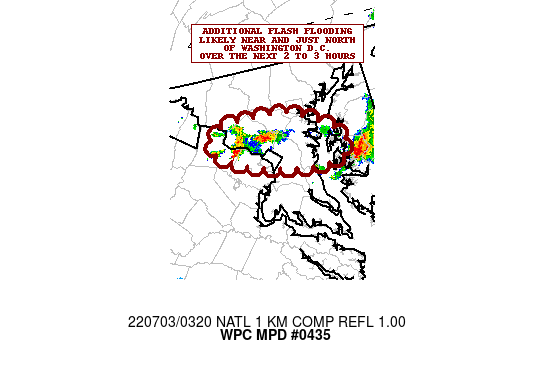
SUMMARY...Locally training and backbuilding showers and
thunderstorms continue across portions of the I-95 corridor just
north and west of the Washington D.C metropolitan area. Additional
areas of flash flooding are likely over the next 2 to 3 hours.

DISCUSSION...Scattered showers and thunderstorms with very heavy
rainfall rates continue to impact areas of the I-95 corridor in
between Washington D.C and Philadelphia and stretching over into
the Delmarva region. The cells of strongest interest right now
involve the small cluster of backbuilding thunderstorms over
Montgomery County, MD and the upstream cells redeveloping over
Loudoun County, VA.

Despite earlier convection, and subsequent boundary layer
stabilization from convective outflow, there is still a rather
robust near-surface instability gradient across the region from
northern VA east-northeast across the northern Delmarva with
MLCAPE values still of as much as 1500 to 2000+ j/kg in place.
Deep moisture remains well entrenched across the region, with PWs
locally over 2 inches (noting the 00Z IAD upper-air sounding) and
recent NESDIS Blended-TPW plots.

Over the next 2 to 3 hours, there will be additional concerns for
convective development given weak shortwave energy approaching the
region from the OH Valley, the slow approach of an upstream cold
front, and the local pooling of instability with multiple outflow
boundary considerations still in play as well.

Expect some additional concerns for repeating and backbuilding
convection, especially near and just north of the Washington D.C.
Rainfall rates will continue to be as high as 2.5 inches/hour, and
additional rainfall amounts of 3 to 4 inches will be possible
going through 06Z. Expect conditions to improve thereafter,
however, additional areas of flash flooding are expected over the
next 2 to 3 hours.

Orrison

ATTN...WFO...LWX...PHI...

ATTN...RFC...MARFC...NWC...

LAT...LON   39287678 39137640 38967614 38767627 38777679
            38937744 39097765 39277750
Last Updated: 1124 PM EDT Sat Jul 02 2022
|


