| WPC Met Watch |
|
|
Mesoscale Precipitation Discussion: #0439 |
|
(Issued at 1135 PM EDT Sat Jun 14 2025
) |
|
| MPD Selection |
|
|
|
|
|

Mesoscale Precipitation Discussion 0439
NWS Weather Prediction Center College Park MD
1135 PM EDT Sat Jun 14 2025

Areas affected...much of north-central and northeast OK and
portions of far south-central and southeast KS

Concerning...Heavy rainfall...Flash flooding likely

Valid 150340Z - 150940Z

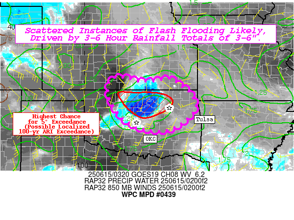
Summary...Scattered instances of flash flooding are likely, driven
by 3-6 hour rainfall totals of 3-6" (with the potential for
localized 6"+ totals over portions of north-central OK).

Discussion...Convection has initiated and gradually proliferated
over the past few hours over portions of north-central OK and far
south-central and southeast KS, in advance of a slow moving
shortwave/remnant mesoscale convective vortex (MCV). The region is
situated within an area of favorable northwest flow aloft, and the
shortwave/MCV is providing 30-40 kts worth of deep layer (0-6 km)
shear for convective organization and storm longevity. A
substantial gradient of ML CAPE (500-3500 J/kg) is also situated
over the area, paralleling a quasi-stationary surface boundary
(quite evident in the surface thetaE gradient) that is draped from
NNW to SSE from north-central OK southward to southeast OK.
Tropospheric moisture content remains very highly anomalous,
ranging from 1.7-2.1" (near the max moving average, per OUN
sounding climatology). This is supporting highly efficient
instantaneous rainfall rates of up to 3-5"/hr (per MRMS
estimates), due to wet bulb zero heights around 13k-14k feet (also
near the max moving average, per OUN sounding climatology). This
is already allowing for localized hourly totals of 1-2" with
ongoing convection (with modest cell motions of 10-20 kts), but
these hourly totals could start to approach 3-4" as convection
begins to backbuild towards the northwest. This backbuilding will
be facilitated by a strengthening, veering low-level jet (LLJ),
resulting in idealized isentropic lift near the 305K surface
(along with warm air advection and increasing ML CAPE through the
overnight hours).

Hi-res CAMs are overall in quite good agreement concerning the
convective evolution and resulting QPF overnight, suggesting
localized 3-6" totals (and possibly even exceeding 6" in an
isolated spot or two in north-central OK). While totals in this
range may only meet or slightly exceed 6-hr Flash Flood Guidance
(FFG), much of this QPF is likely to fall within a 3-hr period
(per 00z HREF 40-km neighborhood 3"/3-hr exceedance probabilities
of 20-50% between 06-09z). Between the 3-hr and 6-hr expected
totals, probabilities of exceeding FFGs (per the HREF 40-km
neighborhood exceedance probs) are between 30-60%. While it is
likely that the most extreme totals will stay north of OKC and
west of Tulsa (mitigating the impacts to large population
centers), localized 5" exceedance (per HREF probs) is suggested to
be as high as 25-35% (corresponding to 10-15% odds of 100-yr ARI
exceedance). Experimental hourly RRFS runs since 18z have also
consistently depicted this potential, concerningly even suggesting
the potential for 7-9" localized totals. Given the very favorable
environment for training heavy rainfall and the consistent hi-res
signals, scattered instances of flash flooding are considered
likely (with localized considerable flash flooding possible).

Churchill

ATTN...WFO...DDC...ICT...OUN...TSA...

ATTN...RFC...TUA...NWC...

LAT...LON   37589811 37459759 37409711 37429654 37559594
            37179535 36709488 36029476 35149593 35189727
            35689819 36489874 37199885 37579864
Download in GIS format: Shapefile
| KML
Last Updated: 1137 PM EDT Sat Jun 14 2025
|


