| WPC Met Watch |
|
|
Mesoscale Precipitation Discussion: #0445 |
|
(Issued at 255 PM EDT Sun Jun 15 2025
) |
|
| MPD Selection |
|
|
|
|
|

Mesoscale Precipitation Discussion 0445
NWS Weather Prediction Center College Park MD
255 PM EDT Sun Jun 15 2025

Areas affected...Portions of the Southeast U.S.

Concerning...Heavy rainfall...Flash flooding possible

Valid 151855Z - 160000Z

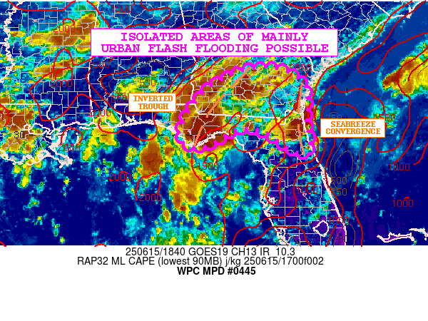
SUMMARY...Slow-moving heavy showers and thunderstorms will
continue through the afternoon and early evening hours across
southern GA into eastern portions of the FL Panhandle and through
northeast FL. Isolated areas of mainly urban flash flooding will
be possible.

DISCUSSION...The latest GOES-E IR satellite imagery shows
expanding clusters of heavy showers and thunderstorms across areas
of southern GA into the FL Panhandle and northeast FL. The
convection is focused generally near a weak inverted surface
trough and in a weakly divergent flow regime aloft due to an
upper-level trough near the Gulf Coast. Additionally, there is
evidence of some seabreeze convergence more specifically attached
to to the convective threat over northeast FL

MLCAPE values of 2000 to 3000 J/kg and high PWs of locally over 2
inches will support rainfall rates of 2 to 3 inches/hour with the
stronger convective cores near the inverted trough axis. Slow
cell-motions and a couple of cell-mergers may yield some spotty
totals of 3 to 4+ inches going through early this evening. The
latest HRRR and RRFS guidance supports this with some 12Z HREF
guidance also favoring locally heavy rainfall amounts.

A few isolated areas of mainly urban flash flooding will be
possible as a result going through early this evening. Some areas
that saw heavy rain yesterday may also be impacted which will
introduce some localized runoff concerns.

Orrison

ATTN...WFO...CHS...FFC...JAX...TAE...

ATTN...RFC...ALR...NWC...

LAT...LON   32188313 32078195 31618142 31118129 30518136
            29488121 29468170 30118272 30218360 29748440
            29598502 30088551 31458463
Download in GIS format: Shapefile
| KML
Last Updated: 255 PM EDT Sun Jun 15 2025
|


