| WPC Met Watch |
|
|
Mesoscale Precipitation Discussion: #0453 (2023) |
|
(Issued at 918 PM EDT Fri Jun 09 2023
) |
|
| MPD Selection |
|
|
|
|
|

Mesoscale Precipitation Discussion 0453
NWS Weather Prediction Center College Park MD
918 PM EDT Fri Jun 09 2023

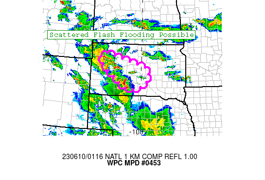
Areas affected...Central and Western SD

Concerning...Heavy rainfall...Flash flooding possible

Valid 100117Z - 100617Z

Summary...Slow moving convection may pose an isolated to scattered
flash flood risk over the next several hours across portions of
central and western South Dakota.

Discussion...Across portions of central and western SD slow moving
convection is ongoing along an axis of enhanced lower level
convergence near a surface trough and ahead of southward dropping
cold front. Shear profiles are pretty weak, but strong upper level
diffluence is noted across the region...likely allowing cells to
persist/organize a bit more than the weak shear would otherwise
allow. In the lower levels an area of low pressure over western SD
is likely enhancing convergence...and it is the persistence of
this convergence combined with the mid/upper forcing that will
support some slow moving convection across the area for the next
several hours. Activity is currently slow moving and exhibiting
some backbuilding/training characteristics as cells build into the
ongoing convection within the low level easterly flow. MLCAPE is
currently around 1500-2000 J/KG within this inflow region, which
should support several more hours of convection that will only
slowly progress eastward. Thereafter eroding instability should
result in a gradual weakening trend, with the cold front pushing
south of the region as well.

The 18z HREF neighborhood probabilities of 3"+ are over 40%, and
EAS probabilities of 1" are 25-35%. This supports the idea of
localized amounts exceeding 3" across central/western SD, with the
elevated EAS probabilities indicating some organization of this
heavy rain. Amounts of this magnitude are also supported by recent
HRRR runs and MRMS QPE estimates. The HREF probabilities seem a
bit displaced to the north of reality, while the 23z HRRR is doing
a better job (although possibly a bit too far south). While this
region has not been as wet over the past couple weeks as MT,
isolated to scattered FFG exceedance is still expected, which may
result in some flash flood impacts over the next few hours.

Chenard

ATTN...WFO...ABR...UNR...

ATTN...RFC...MBRFC...NWC...

LAT...LON   45410305 45300250 45020134 44780043 44609968
            44359945 43739963 43390045 43460123 44210231
            44640289 45220323
Last Updated: 918 PM EDT Fri Jun 09 2023
|


