| WPC Met Watch |
|
|
Mesoscale Precipitation Discussion: #0453 |
|
(Issued at 951 PM EDT Sun Jun 15 2025
) |
|
| MPD Selection |
|
|
|
|
|

Mesoscale Precipitation Discussion 0453
NWS Weather Prediction Center College Park MD
951 PM EDT Sun Jun 15 2025

Areas affected...South-Central to Southeast MO...Much of Southwest
to Central and Northeast AR

Concerning...Heavy rainfall...Flash flooding likely

Valid 160150Z - 160730Z

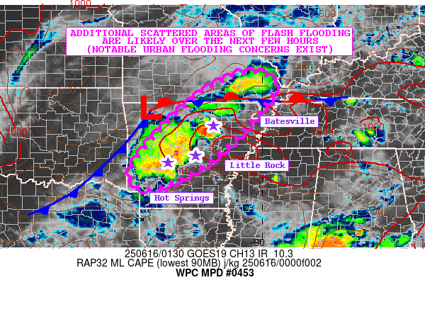
SUMMARY...Additional scattered areas of flash flooding are
expected over the next few hours, which will include some urban
flooding concerns as areas of slow-moving and locally training
showers and thunderstorms continue to impact areas of
south-central to southeast MO down through large areas of central
to southwest AR.

DISCUSSION...The evening GOES-E IR satellite imagery along with
radar data shows broken bands of heavy showers and thunderstorms
impacting parts of south-central to southeast MO, and especially
down through central to southwest AR where there has recently been
some notable cell-training of the activity. The convection is
entrenched within a convergent low to mid-level flow regime around
the southern flank of a deeper layer low center over the Ozark
Plateau.

The airmass remains very moist and unstable with MLCAPE values
over portions of central to northeast AR on the order of 1500 to
2500+ J/kg. PWs are as high as 2.0 to 2.25 inches and near the
90th percentile of climatology. As a result, rainfall rates with
the ongoing convection remain quite high with magnitudes of 2 to 3
inches/hour with the stronger cells.

Convergent flow over southeast through central AR and to a lesser
extent up through southeast MO will continue to promote these
slow-moving convective bands in the near-term. However, as
instability gradually wanes, the activity by late this evening
should weaken.

The HRRR and RRFS guidance suggests locally an additional 2 to 4+
inches of rain going through midnight, and these rains are
generally expected to produce scattered areas of additional flash
flooding. This will include concerns over the next few hours for
some urban flooding impacts, and especially where any additional
cell-training occurs before the activity weakens.

Orrison

ATTN...WFO...LSX...LZK...MEG...PAH...SGF...SHV...

ATTN...RFC...ORN...TUA...NWC...

LAT...LON   37449000 36808968 34819149 33799328 33839420
            34589416 36369254 37319106
Download in GIS format: Shapefile
| KML
Last Updated: 951 PM EDT Sun Jun 15 2025
|


