| WPC Met Watch |
|
|
Mesoscale Precipitation Discussion: #0456 |
|
(Issued at 728 AM EDT Mon Jun 16 2025
) |
|
| MPD Selection |
|
|
|
|
|

Mesoscale Precipitation Discussion 0456
NWS Weather Prediction Center College Park MD
728 AM EDT Mon Jun 16 2025

Areas affected...South-central to Southeast MN...North-central to
Northeast IA...

Concerning...Heavy rainfall...Flash flooding possible

Valid 161130Z - 161530Z

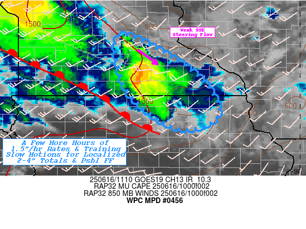
SUMMARY...A few more hours of warm-advective thunderstorms with
slow cell motions or weak training profile resulting in localized
2-4" totals and possible flash flooding.

DISCUSSION...RAP analysis denotes a small well of uncapped MUCAPE
across south-central to southeastern MN into IA along the
southeasterly periphery of a well defined surface warm front
extending from a surface low/triple-point near ATY in eastern
SDAK.  Solid southerly flow intersects and veers becoming
increasingly convergent through the upglide over the front to
provide sufficient WAA to have maintained scattered convection for
the past few hours.  However, trends continue to support further
rooting toward the front across Freeborn county slowly extending
northward toward Sibley county, effectively along/parallel to the
deeper layer steering flow.  While the steering flow is weak to
allow for fairly stationary cell motions, any motions generally
are parallel to the frontal zone allowing for some
cross-over/repeating of the cores of the cells. CIRA LPW along
with RAP analysis denotes a 700mb wave and peak moisture pool
across SE MN providing both the steering and the enhanced deeper
layer moisture; though that is generally moderate to above average
at about 1.5-1.7" in total.  Inflow at cloud base is only about
mid 60F Tds so efficiency is mid-level at about 1.5"/hr
occasionally reaching 2" with pulses of WAA.  Allowing for overall
totals to be highly concentrated but starting to near 3" localized
maxima.

The greatest uncertainty remains on how long the favorable upglide
can maintain give stronger upglide is likely to increased deeper
layer cell motions and break up the more favored repeating
environment, though even slight veering more westward in the
lowest layers will also disrupt the setup.   At this time, most
guidance is traditionally slow with the upstream wave and have
been suggesting a 15z disruption/end to ideal setup; however,
typical model bias would suggest an hour or two faster and given
upstream trends on the overall wave, this seems plausible.  As
such a few more hours can be expected likely expanding the 2-3"
footprint with localized further increase to near 4" possible.
Given FFG in the 1.5-2"/hr and 2-3"/3hr values, exceedance is
probable and result in possible localized incident or two of flash
flooding conditions through 15z before shifting southeast into NE
IA with reduced overall totals.

Gallina

ATTN...WFO...ARX...DMX...MPX...

ATTN...RFC...MSR...NWC...

LAT...LON   44839378 44129256 43669209 43079186 42759247
            42919314 43559390 44189415 44799420
Download in GIS format: Shapefile
| KML
Last Updated: 728 AM EDT Mon Jun 16 2025
|


