| WPC Met Watch |
|
|
Mesoscale Precipitation Discussion: #0457 (2022) |
|
(Issued at 611 AM EDT Wed Jul 06 2022
) |
|
| MPD Selection |
|
|
|
|
|

Mesoscale Precipitation Discussion 0457
NWS Weather Prediction Center College Park MD
611 AM EDT Wed Jul 06 2022

Areas affected...OH Valley into the Central Appalachians

Concerning...Heavy rainfall...Flash flooding possible

Valid 061010Z - 061610Z

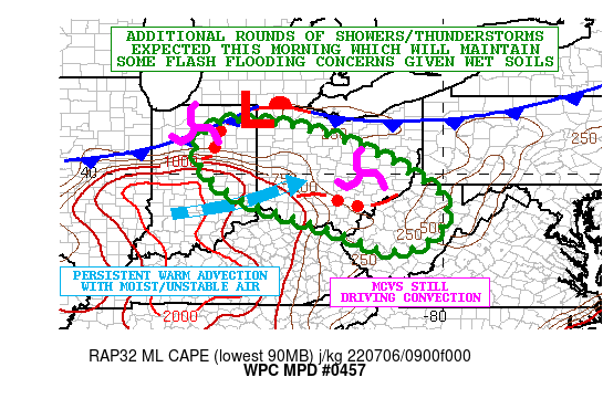
SUMMARY...Additional rounds of showers and thunderstorms are
expected this morning which should maintain at least a regional
threat for some flash flooding given the wet antecedent conditions.

DISCUSSION...Radar and satellite imagery show multiple broken
clusters of convection impacting the OH Valley, with one cluster
continuing to edge through central and southeast OH, and another
more progressive cluster advancing east through northern IN.
Multiple MCVs remain in play early this morning with this
activity, and the one associated with the convection across
northern IN is generally the strongest piece of energy and
continues to interact with a pool of moderate instability with
MLCAPE values of 1500 to 2000+ j/kg pooling north from central KY
up across much of southern/central IN in advance of the
approaching energy. A well defined outflow boundary/front is also
draped across the region and is favoring areas of stronger surface
convergence.

Over the next several hours going through mid-morning, additional
pockets of locally heavy showers and thunderstorms may continue
across the broader upper OH Valley region in particular with some
concerns for this edging into the central Appalachians as well.
Very warm and moist air continues to advance across the broader OH
Valley ahead of a frontal system advancing down from the north,
and by later this morning, the onset of diurnal
heating/surface-based instability may allow for ongoing activity
to regain some stronger organization and redevelopment with
heavier rainfall rates.

PWs of 1.75 to 2.0 inches are in place, and this coupled with the
lingering instability should continue to favor at least some
pockets of convection this morning capable of producing rainfall
rates of up to 1.5 inches/hour. Locally an additional 2 to 3
inches of rain is possible where some of these cells continue to
repeat over the same area, which has been a concern for several
hours now across areas of central and southeast OH with the
convection in this area.

Many areas are seeing soil conditions now very moist if not
saturated, and the additional rainfall this morning albeit in a
weakened state, may result in some additional localized flash
flooding or at least exacerbating ongoing runoff concerns.

Orrison

ATTN...WFO...CLE...ILN...IND...IWX...PBZ...RLX...

ATTN...RFC...NCRFC...OHRFC...NWC...

LAT...LON   41338545 41118354 40388155 39478015 38758000
            38148066 38078165 38568280 39288502 40128618
            40928626
Last Updated: 611 AM EDT Wed Jul 06 2022
|


