| WPC Met Watch |
|
|
Mesoscale Precipitation Discussion: #0467 |
|
(Issued at 752 AM EDT Tue Jun 17 2025
) |
|
| MPD Selection |
|
|
|
|
|

Mesoscale Precipitation Discussion 0467
NWS Weather Prediction Center College Park MD
752 AM EDT Tue Jun 17 2025

Areas affected...Central KS...Far Northern OK

Concerning...Heavy rainfall...Flash flooding possible

Valid 171152Z - 171531Z

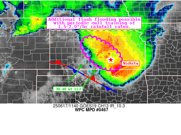
Summary...Convection has developed upstream of an intense bowing
segment along the KS-OK border. Periodic training of these upwind
cells containing max hourly rainfall rates of 1.5-2"/hr could
support additional flash flooding this morning.

Discussion...Radar depicts an axis of convection developing across
Central KS, upstream of an intense bowing segment currently
located along the KS-OK border. While this bowing segment is
rapidly forward propagating, 2"/hr rainfall rates led to several
reports of flash flooding in the Wichita area earlier, with
additional reports received to the north in McPherson from the
upstream activity.

Objective analysis output suggests the environment in the wake of
this bowing segment will support the maintenance of training cells
for several more hours as a 30-40 kt nocturnal LLJ bisects a NW-SE
oriented stationary front, which was parallel to the NW'ly
effective shear vectors amid 2000-3000 MUCAPE and 1.4-1.7" PWATS.

The HRRR suggests localized amounts upwards of 1.5-2.5" are
possible through 15Z, in addition to the 2-3" estimated earlier.
Thus, additional instances of flash flooding are possible where
these cells can train before the nocturnal LLJ begins to weaken
around 15z, particularly over the Wichita and McPherson areas
currently experiencing flash flooding.

Asherman

ATTN...WFO...DDC...GID...ICT...TOP...

ATTN...RFC...KRF...TUA...NWC...

LAT...LON   39459879 38629718 37779656 37119678 37119769
            37779874 38959953
Download in GIS format: Shapefile
| KML
Last Updated: 752 AM EDT Tue Jun 17 2025
|


