| WPC Met Watch |
|
|
Mesoscale Precipitation Discussion: #0473 |
|
(Issued at 441 PM EDT Tue Jun 17 2025
) |
|
| MPD Selection |
|
|
|
|
|

Mesoscale Precipitation Discussion 0473
NWS Weather Prediction Center College Park MD
441 PM EDT Tue Jun 17 2025

Areas affected...Northwest IA...Northeast NEB...Far Southeast
SDAK...Far Southwest MN...

Concerning...Heavy rainfall...Flash flooding possible

Valid 172040Z - 180200Z

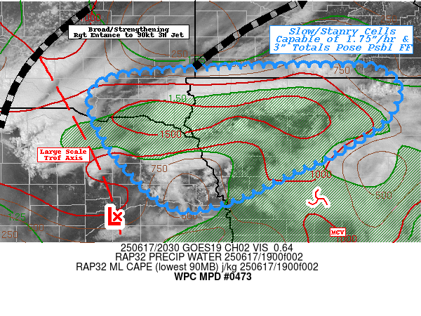
SUMMARY...Very slow/stationary cells along/north of deeper layer
upper-low with favorable outflow to maintain cells.  However,
limited instability/moisture may limit overall coverage to be
widely scattered, but highly focused with localized spots of 2-3"
and flash flooding possible.

DISCUSSION...GOES-E WV suite shows the core of the large
scale/global trough is slowly shifting eastward across central to
eastern NEB with and old smaller scale MCV preceding it across
central IA.  Developing convection along/north has very
long/narrow anvils with cirrus tails expanding well downstream
indicative of the very favorable right entrance divergence to the
expanding/accelerating jet 90kt 3H jet over the eastern Dakotas
into northern MN.  Additionally, those larger mid-level waves
produced extensive clouds across southeast NEB and central IA
inhibiting solar heating this afternoon and sharpening the
differential heating boundary and keeping instability generally
through the Missouri River Valley an back toward the NEB
Sandhills.  Remaining pockets of 1500-2000 J/kg of MLCAPE will
provide solid updraft strength for scattered coverage across the
area of concern.

Low level flow continues to provide some weak southerly moisture
advection into the deeper layer deformation zone/axis across NW IA
where Total PWat values are a modest 1.5" though convergence/flux
will help to provide that boost for solid rainfall production at
about 1.75"/hr.  Given slow cell motions, some locations have
already experienced over 3" resulting in localized flash flooding
along the SDAK/IA state line.   Weak cold pools are helping with
some cell motions, weakly propagating southward into the 15-20kts
of inflow and toward remaining pockets of instability.  As such,
further expansion of 2-3" areal coverage is possible to expand
flooding conditions, particularly south into the flow and eastward
along the deformation zone north of the MCV.   As such, localized
flash flooding remains possible this evening until instability is
fully exhausted.

Note: Similar evolution/cell development is occurring west across
the Sand Hills, given very high FFG values and infiltration
capability, have only expanded the western edge of the MPD area to
the eastern edge these sandy soil areas.

Gallina

ATTN...WFO...DMX...FSD...MPX...OAX...

ATTN...RFC...KRF...MSR...NWC...

LAT...LON   43699395 43629339 43349306 42959319 42709343
            42259417 41889497 41439602 41439694 42539797
            43399805 43639641
Download in GIS format: Shapefile
| KML
Last Updated: 441 PM EDT Tue Jun 17 2025
|


