| WPC Met Watch |
|
|
Mesoscale Precipitation Discussion: #0477 |
|
(Issued at 1256 PM EDT Wed Jun 18 2025
) |
|
| MPD Selection |
|
|
|
|
|

Mesoscale Precipitation Discussion 0477
NWS Weather Prediction Center College Park MD
1256 PM EDT Wed Jun 18 2025

Areas affected...Eastern OH Valley...Northern Mid
Atlantic...Interior Northeast

Concerning...Heavy rainfall...Flash flooding possible

Valid 181656Z - 182256Z

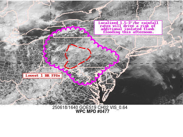
Summary...Shallow thunderstorms are gradually expanding in
coverage and intensity across the Eastern OH Valley, Northern
Mid-Atlantic, and Interior Northeast. Periods of repeating cells
containing 1.5 to locally 2"/hr rainfall rates could support
additional isolated flash flooding this afternoon in light of
recent heavy rainfall in the region.

Discussion...Day Cloud Phase RGB and LightningCast data suggest
shallow thunderstorms across the Eastern OH Valley, Northern
Mid-Atlantic, and Interior Northeast are intensifying as an
extremely moist airmass destabilizes beneath eroding low-level
clouds. The most persistent cells were initially roughly along
I-80 in Western PA, which prompted several Flash Flood Warnings as
they repeated over an area impacted yesterday and realized
1.5-1.8"/hr rainfall rates per KCCX. Additional flooding was also
noted near Buffalo, NY as an axis of cells stalled and trained
overhead.

As highlighted in the 12Z soundings from PIT and IAD, the airmass
across the region remains very supportive for efficient warm rain
production in these cells, with saturated profiles containing
1.7-2.1" PWATs, 1000-2000 J/KG of MUCAPE, and warm cloud layers of
13,000-14,000 feet noted. Sufficient shear remains as well to
support at least loosely organized multicellular storm modes, with
20-35 kts depicted in recent mesoanalysis.

Over the next several hours, a general trend of expanding
multicells is expected as a weak shortwave over Western OH
approaches from the west amid continued surface heating. Westerly
steering flow should permit for periods of repeating cells,
although storm coverage should remain more scattered compared to
yesterday's event. As instability builds and additional cells
form, both the HREF and REFS neighborhood probabilities show an
increasing likelihood of at least 1"/hr rates and 1-3 HR FFG
exceedance beginning around the 17-18z time frame. With FFGs in
the region as low as .25-1.5", additional isolated flash flooding
is possible as these cells expand and periodically repeat.

Asherman

ATTN...WFO...BGM...BUF...CLE...CTP...LWX...PBZ...PHI...

ATTN...RFC...RHA...TAR...TIR...NWC...

LAT...LON   42617863 42507757 41357647 40507484 39587600
            38627691 38617789 39237850 39597895 40118005
            40778037 41508026 42247970
Download in GIS format: Shapefile
| KML
Last Updated: 1256 PM EDT Wed Jun 18 2025
|


