| WPC Met Watch |
|
|
Mesoscale Precipitation Discussion: #0478 |
|
(Issued at 201 PM EDT Wed Jun 18 2025
) |
|
| MPD Selection |
|
|
|
|
|

Mesoscale Precipitation Discussion 0478
NWS Weather Prediction Center College Park MD
201 PM EDT Wed Jun 18 2025

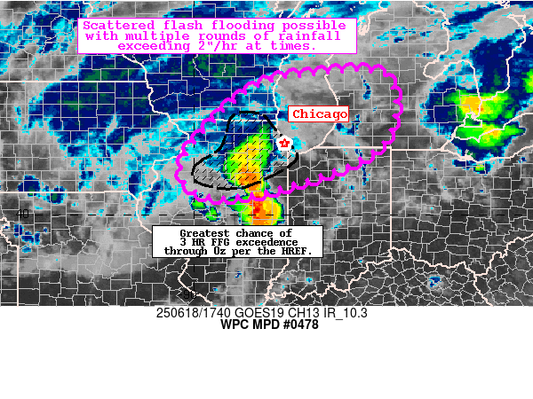
Areas affected...Northeast IL (including the Chicago
Metro)...Southwest MI

Concerning...Heavy rainfall...Flash flooding possible

Valid 181800Z - 190000Z

Summary...Intense convective complex is translating through IL.
Scattered flash flooding -- some of which could be locally
significant in/near the Chicago metro -- is possible this
afternoon.

Discussion...Intense convective complex continues to track across
Central IL ahead of a well defined MCV located northeast of St.
Louis. The leading corridor of cells was along a NW-SE axis, and
generally forward propagating to the northeast at around 30-40
kts, with an area of showers and thunderstorms wrapping around the
northwest of the MCV, upstream of the forward propagating
activity. Max rainfall rates within this complex were generally on
the order of 1.5"/hr.

Recent mesoanalysis and GPS data suggest a very moist and unstable
airmass is advecting ahead of the complex, with 1.7-1.9" PWATS and
3000-4500 J/kg of MLCAPE depicted in the pre-convective
environment. Recent GOES-E DMW also placed the right entrance
region of a jet streak over Lake Michigan and Wisconsin to further
enhance forcing for ascent ahead of the MCV. As this complex
translates northeastward within 40-50 kts of effective shear,
multiple rounds of precipitation are possible in the MPD area from
1) individual cells within the right entrance region of the jet
streak, 2) along the leading edge of the forward propagating
component and 3) beneath the northwest flank of the MCV.

Over the next several hours, the HREF suggests increasing
probabilities of 2"/hr rainfall rates as this repeating of
precipitations occurs. Accordingly, scattered flash flooding may
result with the HREF suggesting localized rainfall amounts of 2-4"
may fall where these three rounds of precipitation can overlap.
Localized significant flash flooding is possible in sensitive
urbanized areas, including the Chicago metro.

Asherman

ATTN...WFO...DVN...GRR...ILX...IWX...LOT...MKX...

ATTN...RFC...MSR...TIR...NWC...

LAT...LON   43698684 43628491 41858506 40788753 40498960
            41379028 43198864
Download in GIS format: Shapefile
| KML
Last Updated: 201 PM EDT Wed Jun 18 2025
|


