| WPC Met Watch |
|
|
Mesoscale Precipitation Discussion: #0481 |
|
(Issued at 110 AM EDT Thu Jun 19 2025
) |
|
| MPD Selection |
|
|
|
|
|

Mesoscale Precipitation Discussion 0481
NWS Weather Prediction Center College Park MD
110 AM EDT Thu Jun 19 2025

Areas affected...Central/Eastern AR...Central/Western
TN...Southwest KY

Concerning...Heavy rainfall...Flash flooding possible

Valid 190510Z - 191030Z

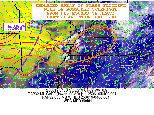
SUMMARY...Some expansion of heavy shower and thunderstorm activity
is expected over the next few hours. Some cell-training concerns
are expected, and with high rainfall rates, some isolated areas of
flash flooding will be possible.

DISCUSSION...GOES-E WV suite shows a digging shortwave trough
across the Midwest, with the leading edge of height falls
impinging on the lower/middle MS Valley. This energy is beginning
to interact with a strong instability gradient that is in place
across central/eastern AR, western TN and parts of southwest KY.
MLCAPE values are on the order of 1500 to 2500 J/kg locally, and
despite the negative influence of boundary layer CIN, recent IR
satellite imagery shows cooling convective tops becoming better
established across eastern AR and into far western TN.

A modest southwest low-level jet currently oriented across the
region is expected to strengthen and become more convergent over
the next few hours and reach 30 to 40+ kts. This will strengthen
the moisture transport across the area, but will also foster
stronger low-level forcing into an area that is already unstable.

A combination of these factors will support some expansion of the
current convective activity, with heavy showers and thunderstorms
also becoming a bit better aligned with the deeper layer mean flow
which will support a cell-training threat. PWs are quite moist
with values of 1.8 to 2.0 inches based on 00Z RAOB soundings and
recent GPS-derived data. The CIRA-ALPW data shows a substantial
level of moisture concentrated in the mid-levels of the column
where much of the vertical ascent will be taking place.

This suggests convection capable of high rainfall rates that may
reach 1.5 to 2.5 inches/hour which is generally supported by the
00Z HREF guidance. However, with the cell-training concerns, some
storm totals by dawn may reach 3 to 4+ inches. The HREF guidance
does show some low-end FFG exceedance probabilities, and thus the
expectation is that some isolated areas of flash flooding will be
possible.

Orrison

ATTN...WFO...HUN...LMK...LZK...MEG...OHX...PAH...

ATTN...RFC...ORN...TIR...TUA...NWC...

LAT...LON   37368825 37328650 36598599 35558663 34808852
            34389048 34589252 35559271 36148994
Download in GIS format: Shapefile
| KML
Last Updated: 110 AM EDT Thu Jun 19 2025
|


