| WPC Met Watch |
|
|
Mesoscale Precipitation Discussion: #0482 |
|
(Issued at 600 AM EDT Thu Jun 19 2025
) |
|
| MPD Selection |
|
|
|
|
|

Mesoscale Precipitation Discussion 0482
NWS Weather Prediction Center College Park MD
600 AM EDT Thu Jun 19 2025

Areas affected...Eastern AR...Southwest TN...Northern
MS...Northern AL

Concerning...Heavy rainfall...Flash flooding possible

Valid 191000Z - 191500Z

SUMMARY...A well-organized band of heavy showers and thunderstorms
will continue to pose a threat for some additional flash flooding
going through the mid-morning hours.

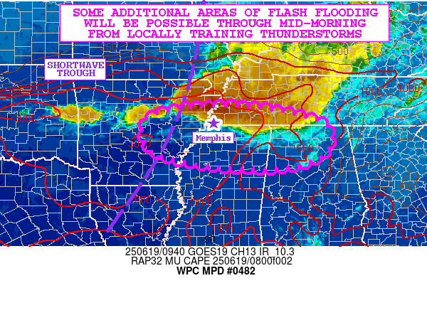
DISCUSSION...Early morning GOES-E IR satellite imagery shows a
west to east oriented axis of heavy showers and thunderstorms
extending from northeast AR through much of southwest TN and with
a portion of the line losing latitude and edging into northeast MS
and northern AL.

The cold-topped convection has been showing a considerable amount
of cell-training over the last couple of hours across southwest TN
as the activity becomes aligned with the deeper layer steering
flow. All of the convection continues to be facilitated by the
pooling of a very moist and unstable airmass that is in place
ahead of a shortwave trough advancing east toward the OH Valley
and Mid-South. MLCAPE values are rather impressive early this
morning across central to eastern AR and into southwest TN with a
corridor of 2000 to 3000 J/kg of CAPE aligned with a convergent
west-southwest low-level jet of 30 to 40 kts.

This coupled with at least some modest shear will likely maintain
the convective organization of this linear MCS for at least a few
more hours. PWs are quite moist with values of 1.8 to 2.0 inches
based on recent GPS-derived data, and the depth of moisture
coupled with the instability and strength of the low-level jet
should maintain high rainfall rates that will likely be on the
order of 1.5 to 2.5 inches/hour.

The latest hires CAMs suggest some additional training of
convection may occur through mid-morning with the activity also
gradually settling farther south. This will allow for more areas
of eastern AR, northern MS and northern AL to get into some
heavier rainfall potential. In general across the Mid-South, an
additional 3 to 4 inches of rain will be possible, and this will
include southwest TN where there will be concerns for some of
these rains to impact the Memphis metropolitan area.

Given the additional rainfall potential over the next few hours,
some additional areas of flash flooding will be possible.

Orrison

ATTN...WFO...BMX...HUN...JAN...LZK...MEG...OHX...

ATTN...RFC...ALR...ORN...TUA...NWC...

LAT...LON   35609036 35538830 35008631 34088633 33638759
            33628946 33849109 34299214 35259212
Download in GIS format: Shapefile
| KML
Last Updated: 600 AM EDT Thu Jun 19 2025
|


