| WPC Met Watch |
|
|
Mesoscale Precipitation Discussion: #0483 |
|
(Issued at 1121 AM EDT Thu Jun 19 2025
) |
|
| MPD Selection |
|
|
|
|
|

Mesoscale Precipitation Discussion 0483
NWS Weather Prediction Center College Park MD
1121 AM EDT Thu Jun 19 2025

Areas affected...Southeast AR...North-Central MS...Western AL

Concerning...Heavy rainfall...Flash flooding possible

Valid 191520Z - 191850Z

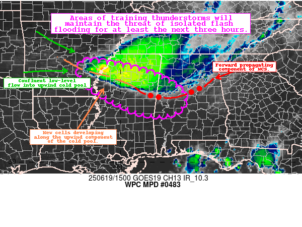
Summary...Periods of training and repeating thunderstorms within a
persistent MCS will maintain the threat of isolated flash flooding
for at least the next three hours.

Discussion...Regional radar highlights a persistent MCS containing
a forward propagating component across Eastern MS and
North-Central AL, with upwind development occurring further west
along a slow moving cold pool. The alignment of these cells was
leading to periods of repeating and training across the
highlighted area, with 1.5-2.6"/hr rainfall rates estimated within
the most intense cells over North-Central MS.

The development of new cells upstream is likely tied to a
confluent low-level regime in the upwind portion of the cold pool
interacting with a very moist and unstable airmass characterized
by 2500 J/kg of MLCAPE (and minimal CIN), 1.8-1.9" PWATs, and
20-25 kts of effective shear to support new development of loosely
organized cells capable of continued 1.5-2.5"/hr rates.
Both the HREF and REFS suggest this training and repeating
activity will continue for at the next three hours -- albeit with
some uncertainty regarding the persistence owing to how CAMs have
struggled with the cold pool. However, the HREF and REFS suggest
localized amounts of 2-3 inches remain possible through 18z, which
could locally breach FFGs in the region and cause isolated flash
flooding.

Asherman

ATTN...WFO...BMX...JAN...LZK...MEG...MOB...

ATTN...RFC...ALR...ORN...NWC...

LAT...LON   34649171 34338950 33968828 33218711 32458722
            32168815 32488964 33669159
Download in GIS format: Shapefile
| KML
Last Updated: 1121 AM EDT Thu Jun 19 2025
|


