| WPC Met Watch |
|
|
Mesoscale Precipitation Discussion: #0486 |
|
(Issued at 319 PM EDT Thu Jun 19 2025
) |
|
| MPD Selection |
|
|
|
|
|

Mesoscale Precipitation Discussion 0486
NWS Weather Prediction Center College Park MD
319 PM EDT Thu Jun 19 2025

Areas affected...Interior New England...

Concerning...Heavy rainfall...Flash flooding possible

Valid 191920Z - 200100Z

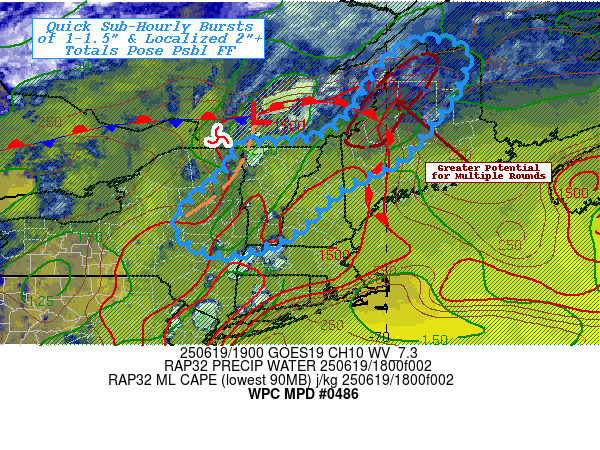
SUMMARY...Intense,efficient rainfall producing thunderstorms with
capability of 1.5-2"/hr rates and some repeating further northeast
into Maine, may result in localized 2-3" totals and possible
incidents of flash flooding given complex/steep terrain.

DISCUSSION...GOES-E WV suite shows a strong/fairly compact
shortwave cyclone crossing the Lower Great Lakes with a broad jet
streak across much of Quebec, resulting in favorable right
entrance ascent downstream into Interior New England.  RAP 500mb
analysis shows a shortwave ridge axis through southern Quebec into
VT and this seems to make a weak southern stream shortwave or
remnant MCV-like feature matched with it.  This wave seems to have
supported a subtle 1001 wave along the stationary front near CWBW,
and a weak surface trof appears within the Champlain Valley and
seems to be a weak convergence zone that extends along the
southern Adirondack Mtns into E NY.  Surface Tds in the upper 60s,
lower 70s expand across the area of concern toward a lifting warm
front from CWHV to BNR to near Portland.  Temperatures have risen
to the mid to upper 80s across VT/N NH supporting MLCAPE rising
into the 1000-1500 J/kg range.  CIRA LPW and RAP analysis also
confirms that moisture as pool along/downstream of this weak
shortwave feature with total Pwats in the 1.75-2" range.  The
combination of factors suggest very heavy rainfall potential will
exist with stronger updrafts crossing the area.

Current RADAR shows steady increase along this convergence trof
and though strongest convergence/moisture is north of the boarder,
the potential for rainfall rates of 2"/hr are solid.  The limiting
factor to reaching those hourly totals will be duration and deep
layer steering is fairly robust at 30-40kts.  As updrafts broaden
streaks of 1.5-2" totals are probable, though best probability for
those totals remains in S Quebec near the low/frontal zone where
convergence can be further maximized.  However, eventually, those
cells will cross back into northern Maine and if there are some
repeating rounds (given upstream forcing remains strong, it seems
possible), spots of 2-3" totals are possible.

Irrespective of totals, the very intense quick burst of 1-1.5"
across complex terrain (1hr FFG in 1.5-2" range) still should pose
localized flash flooding risks...and any increase in duration due
to storms scale interaction/terrain locking would obviously pose a
greater risk, but given Hi-Res CAM solutions/evolution that
evolution remains uncertain and lower confidence overall.

Gallina

ATTN...WFO...ALY...BTV...CAR...GYX...

ATTN...RFC...TAR...NWC...

LAT...LON   47456935 47446854 47216813 46426839 45846880
            44766973 44057114 42997229 42567369 42877469
            43487478 44287387 45077333 45077319 45177170
            45837075 46707025
Download in GIS format: Shapefile
| KML
Last Updated: 319 PM EDT Thu Jun 19 2025
|


