| WPC Met Watch |
|
|
Mesoscale Precipitation Discussion: #0489 |
|
(Issued at 130 AM EDT Sun Jun 22 2025
) |
|
| MPD Selection |
|
|
|
|
|

Mesoscale Precipitation Discussion 0489
NWS Weather Prediction Center College Park MD
130 AM EDT Sun Jun 22 2025

Areas affected...Northern and Central NY

Concerning...Heavy rainfall...Flash flooding possible

Valid 220530Z - 221130Z

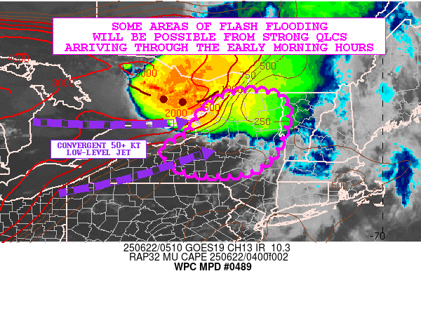
SUMMARY...Strong convective complex over southeast Ontario will be
arriving across northern and central NY over the next several
hours. Some localized cell-training concerns are expected which
may result in some areas of flash flooding early this morning.

DISCUSSION...The latest GOES-E IR satellite imagery along with
MRMS data shows a well-organized QLCS dropping down across
southeast Ontario, with the convective mass associated with a
strong shortwave embedded within deep layer west-northwest flow
situated around the northeast flank of a deep layer subtropical
ridge over the Midwest and Great Lakes region.

Very cold convective tops are noted with the southwest flank of
the convective complex, with some overshooting tops as cold as
about -70C. Strong warm air advection and moisture transport
associated with a 50+ kt southwest low-level jet is seen riding up
across the lower Great Lakes region and far southeast Ontario, and
there is a nose of strong elevated instability aimed into the
southwest flank of the convective mass with MUCAPE values of 2000
to 3000 J/kg.

The robust moisture and instability transport into far southeast
Ontario will begin overspreading areas of northern NY over the
couple of hours as the shortwave energy approaches. This coupled
with strong effective bulk shear values of 40 to 50+ kts will
favor arrival of a well-organized band of convection, with the
QLCS losing latitude and dropping southeastward across northern
and eventually central NY going through early this morning.

Rainfall rates with this activity as it has been traversing
Ontario overnight have been well into the 1 to 2 inch/hour range,
with some cell-training that has fostered storm totals of 2 to 4
inches.

As this activity arrives down across northern and central NY, the
southwest flank of the convective mass may continue to be a focus
for cell-training as some of the convection becomes aligned more
parallel to the deeper layer steering flow. Similar rainfall rates
and totals are expected as this QLCS arrives over the next several
hours, and this may drive at least some areas of flash flooding.

Orrison

ATTN...WFO...ALY...BGM...BTV...BUF...

ATTN...RFC...RHA...TAR...NWC...

LAT...LON   44977381 44537318 43167351 42377450 42337615
            42707711 43227723 43417673 43677638 44447591
            44967497
Download in GIS format: Shapefile
| KML
Last Updated: 130 AM EDT Sun Jun 22 2025
|


