| WPC Met Watch |
|
|
Mesoscale Precipitation Discussion: #0491 |
|
(Issued at 934 AM EDT Sun Jun 22 2025
) |
|
| MPD Selection |
|
|
|
|
|

Mesoscale Precipitation Discussion 0491
NWS Weather Prediction Center College Park MD
934 AM EDT Sun Jun 22 2025

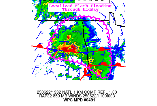
Areas affected...Eastern North Dakota and Northwest Minnesota

Concerning...Heavy rainfall...Flash flooding possible

Valid 221333Z - 221830Z

SUMMARY...Slow moving heavy thunderstorms developing over eastern
ND will continue to shift northeast, but backbuild into the
southwesterly deep layer flow, prolonging rainfall duration.
Localized flash flooding is possible through midday.

DISCUSSION...Latest regional radar and satellite indicate rapid
development of a thunderstorm complex over east-central ND along a
low level trough above a stationary surface front and northwest of
a surface low. Recent rainfall estimates from KMVX have reached 2"
in Foster County in a little less than an hour. This is developing
in a moist/unstable environment. A lobe of elevated moisture (PW
up to 1.8" per the RAP) will continue shifting northeast over the
Red River of the North valley through midday and there is a strong
ML CAPE gradient SW to NE that exceeds 3000 J/kg east of the
current activity.

35kt deep layer SWly flow will keep advecting the moisture north,
though upwind Corfidi vectors point east which should continue to
allow backbuilding. Through midday, rainfall of 1-3" can be
expected in a short time frame/near one hour. 1hr FFG decreases
ahead of the current activity to below 2". Localized exceedance of
FFG is expected to continue, making for a possible flash flood
threat through midday.

Jackson

ATTN...WFO...BIS...FGF...

ATTN...RFC...KRF...MSR...NWC...

LAT...LON   49029618 48289537 46179544 46929730 47309959
            48149933 49009832
Download in GIS format: Shapefile
| KML
Last Updated: 934 AM EDT Sun Jun 22 2025
|


