| WPC Met Watch |
|
|
Mesoscale Precipitation Discussion: #0493 |
|
(Issued at 418 PM EDT Sun Jun 22 2025
) |
|
| MPD Selection |
|
|
|
|
|

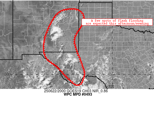
Mesoscale Precipitation Discussion 0493
NWS Weather Prediction Center College Park MD
418 PM EDT Sun Jun 22 2025

Areas affected...portions of far west Texas into eastern New
Mexico

Concerning...Heavy rainfall...Flash flooding likely

Valid 222017Z - 230217Z

Summary...Scattered, slow-moving thunderstorms will continue to
develop across portions of the TransPecos and southeastern New
Mexico this afternoon.  The combination of slow storm movement and
cell mergers should allow for spots of 1-1.5 inch/hr rain rates to
develop, likely prompting flash flooding in a few locales.

Discussion...Scattered thunderstorm activity has materialized
along a surface trough/dryline extending from near SRR/Alto, NM
southward through KVHN/Van Horn, TX.  The storms are in a
marginally sheared environment (20 kts effective shear), but
reside in a zone of persistent low-level convergence and
orographic ascent especially across far west Texas.  1-1.4 inch PW
values, slow storm movement, and occasional cell mergers will
eventually lead to spots of 1-1.5 inch/hr rain rates as storms
mature through the early evening.  An increase in convective
coverage is depicted by CAMs over the next 2-4 hours, which is
reasonable given widespread deepening convective cumulus across
the discussion area amid ~1000 J/kg MLCAPE.

As convective coverage increases this afternoon, 1-1.5 inch/hr
rain rates will fall on areas of sensitive/urban terrain.  1.5
inch/hr FFG thresholds exist across most of the discussion area,
which should be exceeded at times.  Flash flooding is likely on an
isolated to scattered basis through at least 02Z/9p CDT.

Cook

ATTN...WFO...ABQ...AMA...EPZ...LUB...MAF...

ATTN...RFC...FWR...TUA...NWC...

LAT...LON   35830416 35680296 34770267 33090351 31040288
            29950259 29060323 30680499 31630606 33320608
            35260513
Download in GIS format: Shapefile
| KML
Last Updated: 418 PM EDT Sun Jun 22 2025
|


