| WPC Met Watch |
|
|
Mesoscale Precipitation Discussion: #0499 |
|
(Issued at 543 PM EDT Mon Jun 23 2025
) |
|
| MPD Selection |
|
|
|
|
|

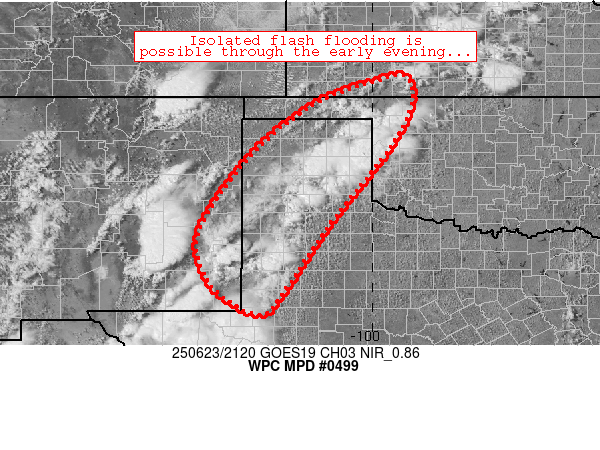
Mesoscale Precipitation Discussion 0499
NWS Weather Prediction Center College Park MD
543 PM EDT Mon Jun 23 2025

Areas affected...portions of the Texas Panhandle, Texas South
Plains, southeastern New Mexico, far northwest Oklahoma, far
southwest Kansas

Concerning...Heavy rainfall...Flash flooding possible

Valid 232142Z - 240342Z

Summary...Scattered, slow-moving thunderstorms were drifting
northward while occasionally merging, resulting in spots of 1-2
inch/hr rain rates.  These trends should continue for a few hours
this afternoon, prompting an isolated flash flood risk especially
in low-lying/sensitive areas.

Discussion...Recent radar mosaic imagery depicts maturing
convective cells in scattered fashion generally extending from
Perryton, TX south-southwestward through Amarillo, Lubbock, and
Hobbs, NM.  These storms were drifting northward amid deep, but
weak, southerly steering flow across the region.  The storms were
embedded in a very moist, unstable pre-convective environment,
with ~2000 J/kg MLCAPE and 1.75-2 inch PW values contributing to
strong updrafts and efficient rain rates.  Weak shear and weak
inhibition has enabled multiple outflow-driven cells to
materialize, with several cell mergers and slow cell movement
contributing to areas of 1.5-3 inch/hr rain rates in a few spots.
Local FFGs are as low as 1.5 inch/hr in spots across the
discussion area, suggestive of isolated flash flood potential
currently existing in the most sensitive areas.

These trends should continue through the evening hours as
continued solar insolation promotes new updrafts/development in
areas unaffected by current convection and outflows.  Models
suggest a diurnally driven convective threat, with gradual
weakening of storms after sunset/02Z or so.  The flash flood
threat will likely be diurnally driven as well.

Cook

ATTN...WFO...ABQ...AMA...DDC...LUB...MAF...OUN...

ATTN...RFC...FWR...TUA...NWC...

LAT...LON   37479921 36939907 35939953 34080098 32490206
            31930264 32580374 33790408 35510295 36810141
            37439978
Download in GIS format: Shapefile
| KML
Last Updated: 543 PM EDT Mon Jun 23 2025
|


