| WPC Met Watch |
|
|
Mesoscale Precipitation Discussion: #0506 |
|
(Issued at 647 PM EDT Tue Jun 24 2025
) |
|
| MPD Selection |
|
|
|
|
|

Mesoscale Precipitation Discussion 0506
NWS Weather Prediction Center College Park MD
647 PM EDT Tue Jun 24 2025

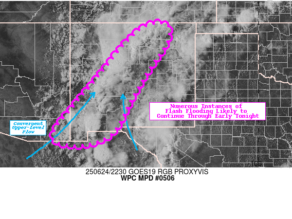
Areas affected...Southwestern and central New Mexico

Concerning...Heavy rainfall...Flash flooding likely

Valid 242246Z - 250446Z

SUMMARY...Numerous showers and thunderstorms are impacting New
Mexico this afternoon and containing hourly rainfall rates up to
2.5". These storms are expected to continue through early tonight
while potentially becoming more organized, likely leading to
numerous additional instances of flash flooding and potentially
significant local impacts.

DISCUSSION...GOES19 IR satellite imagery depicts cooling
cloud-tops associated with thunderstorms oriented
northeast-southwest across New Mexico moving generally
east-northeast under the influence of a large eastern U.S. upper
ridge and western U.S. upper trough. This convergent flow is also
allowing for plentiful amounts of atmospheric moisture content to
continually pump into the region. PWs to remain elevated and above
1.0" in the region, with maximum values along the New
Mexico-Mexico border estimated over 1.6" per SPC's mesoanalysis.
This is well above climatology and highlighted by both the GEFS
and ECENS as exceeding the 95th climatological percentile. To
summarize, any thunderstorms will have ample moisture to produce
efficient rainfall rates of 1.5-2.5"/hr which in this part of the
country can be particularly hazardous.

MLCAPE values over 500 J/kg are widespread across central NM and
higher south where values of 1000-2000 J/kg are being slowly
advected northward along with an MCV in West Texas evident in
visible satellite. The combination of increasing instability,
convergent flow on the western periphery of an MCV, and high PWs
leads to the likelihood of continued convection into the early
overnight period, with thunderstorms also likely congealing along
the primary confluence zone in central NM.

Mountainous terrain, local burn scars, urbanized areas, and dry
washes are most susceptible for flash flooding. Given the ongoing
flash flood warnings in the area and the additional rainfall
amounts locally to exceed 2", additional flash flooding is
considered likely. Some significant impacts are also possible
where renewed/developing convection overlaps with earlier rainfall
associated with initial early afternoon thunderstorms.

Snell

ATTN...WFO...ABQ...EPZ...TWC...

ATTN...RFC...FWR...STR...TUA...NWC...

LAT...LON   36930443 36120439 34730530 33250616 31960683
            31370757 31140869 31300972 31830979 33070882
            34460765 35890651 36820545
Download in GIS format: Shapefile
| KML
Last Updated: 647 PM EDT Tue Jun 24 2025
|


