| WPC Met Watch |
|
|
Mesoscale Precipitation Discussion: #0519 |
|
(Issued at 1149 AM EDT Thu Jun 26 2025
) |
|
| MPD Selection |
|
|
|
|
|

Mesoscale Precipitation Discussion 0519
NWS Weather Prediction Center College Park MD
1149 AM EDT Thu Jun 26 2025

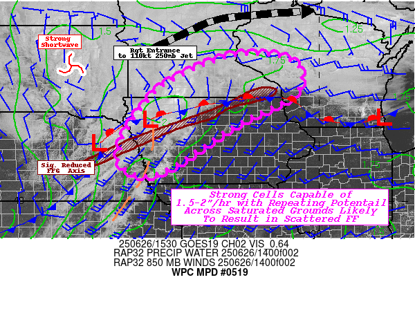
Areas affected...Northern & Western IA...Southern MN...Far Eastern
NEB...Far Southwest WI...

Concerning...Heavy rainfall...Flash flooding likely

Valid 261550Z - 262130Z

SUMMARY...Widely scattered elevated convection with some repeating
elements will increase in coverage/surface rooting throughout the
afternoon with 1.5-2"/hr rates and streaks of 2-3.5" totals over
sensitive solids suggesting possible incidents of flash flooding
by 21z.

DISCUSSION...15z Surface analysis shows main surface low near
Norfolk, NEB with well defined cold front dragging southwest into
north-central KS east of Hill City; while downstream a pre-frontal
pressure trof, generally along the core of the deeper layer
moisture axis/warm conveyor belt extends from another weak low
near CKP through Omaha/Council Bluffs into northeast KS and is
well noted by alto-stratus deck with some isolated weaker
convective cores where sfc to boundary layer convergence is
maximized across western IA.  East of that, clear skies in the
warm sector extend to the surface front being strongly reinforced
through differential heating with extensive low-stratus deck along
the eastern MN/IA border into the Driftless area of SW WI.
SBCAPEs are rising into the upper 3000s J/kg across the clearing,
though solid southerly WAA/ moisture flux along the pressure trof
of 35-40kts, isentropic ascent is starting to increase elevated
convective development along and downstream of the DPVA from the
upper-level trough.  Combine this with highly favorable right
entrance ascent/divergence across NW IA into south-central MN,
convection will continue to develop/expand over the next few
hours.

Orientation of the frontal zone to the mean motion of the
shortwave combined with the steepened isentropes further east,
ascent pattern across north-central IA/southern-MN should see
greatest convective development with stronger/broader updrafts.
Combined with increasing flux convergence, efficient rainfall
production will support rates of 1.5-2"/hr fairly quickly in the
life-cycle.  Additionally, the convergence axis will be broad and
fairly parallel to the boundary and deeper layer flow to support
some repeating cell motions/tracks.  This will be key toward
increased overall rainfall totals nearing 3-3.5" locally given
individual cell motions may limit heavy rainfall duration to those
1.5-2" hourly totals.

Hydrologically, the area remains very saturated with much of IA
and southern MN having 0-40cm relative soil moisture ratios within
the 60-70% range, generally well into the 90th+ percentiles
helping to have confidence that hourly FFG values of 1-1.5" and
3hr at 1.5-2" within the area of concern.  Combine this with the
narrow axis of training cells from last night from Colfax/Dodge,
NEB to Ida/Sac to Humbolt/Wright in IA and Fillmore, MN/Howard, IA
 further compromising upper-soil uptake.  Scattered incidents of
flash flooding will become increasingly likely toward 21z across
the MPD area.

Gallina

ATTN...WFO...ARX...DMX...FSD...MPX...OAX...

ATTN...RFC...KRF...MSR...NWC...

LAT...LON   44909147 44539068 43729072 43139170 42659272
            41149501 40889599 41289672 41919666 42409646
            43649553 44249460 44879298
Download in GIS format: Shapefile
| KML
Last Updated: 1149 AM EDT Thu Jun 26 2025
|


