| WPC Met Watch |
|
|
Mesoscale Precipitation Discussion: #0522 |
|
(Issued at 601 PM EDT Thu Jun 26 2025
) |
|
| MPD Selection |
|
|
|
|
|

Mesoscale Precipitation Discussion 0522
NWS Weather Prediction Center College Park MD
601 PM EDT Thu Jun 26 2025

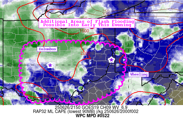
Areas affected...Eastern OH...Northern WV Panhandle...Southwest PA

Concerning...Heavy rainfall...Flash flooding possible

Valid 262200Z - 270200Z

SUMMARY...Ongoing clusters of storms to continue for the next
several hours, prolonging the flash flood threat into this evening.

DISCUSSION...Doppler radar shows scattered, slow-moving
thunderstorms from southwest Ohio and along the Ohio River on east
to far southwest Pennsylvania. The region does lie at the nose of
an unusually strong 50kt ESErly 200mb jet located over the
Southeast. This additional synoptic-scale influence is helping to
provide some upper-level support in a setup that is otherwise
heavily driven by daytime heating and nearby mesoscale boundaries
(outflows, lake breeze off Lake Eire most notably). Storms will
have as much as 2,000 J/kg of MLCAPE at their disposal through the
remainder of the afternoon and into this evening. PWs are also
ranging between 1.8-2.0", supporting the ongoing Excessive
Rainfall rates being observed in central and southwest OH.

Additional thunderstorms will likely come about as a result of
outflow boundaries emanating from ongoing convection, as well as
outflows colliding with other nearby outflow boundaries. Vertical
wind shear is light, making these storms highly dependent upon
cold-pool driven processes and congealing clusters of storms. With
a couple more hours of daylight to go, more storms are likely to
take advantage of the unstable/moist environment, as well as from
the help of an anomalous 200mb jet streak aloft. Additional rounds
of flash flooding are possible within the highlighted at-risk
region through the remainder of this afternoon.

Mullinax

ATTN...WFO...CLE...ILN...IWX...PBZ...RLX...

ATTN...RFC...TIR...NWC...

LAT...LON   40848340 40828140 40528027 39738023 39118046
            38578168 38708279 38668375 39568409 40608399
Download in GIS format: Shapefile
| KML
Last Updated: 601 PM EDT Thu Jun 26 2025
|


