| WPC Met Watch |
|
|
Mesoscale Precipitation Discussion: #0572 (2023) |
|
(Issued at 306 PM EDT Fri Jun 23 2023
) |
|
| MPD Selection |
|
|
|
|
|

Mesoscale Precipitation Discussion 0572
NWS Weather Prediction Center College Park MD
306 PM EDT Fri Jun 23 2023

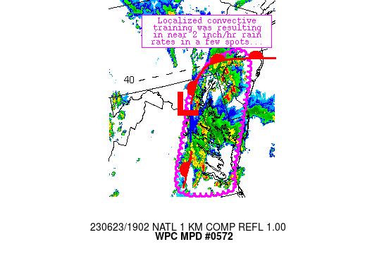
Areas affected...eastern Virginia northward to southeastern
Pennsylvania

Concerning...Heavy rainfall...Flash flooding possible

Valid 231858Z - 240058Z

Summary...A few areas of training convective have materialized
over the past 30 minutes, with 2 inch/hr rain rates noted per
MRMS.  Flash flooding is possible with this activity.

Discussion...Gradually deepening convection has begun to focus
along an axis extending from near Philadelphia, PA to near
Richmond, VA over the past 30-45 minutes.  The storms are in a
very weakly forced environment, although lift/ascent associated
with a weak cold front/surface boundary appears to be the primary
driving mechanism for the linear organization.  Instability/shear
profiles support efficient rainfall processes from individual
cores due to 1.9 inch PW values and areas of 1000 J/kg MLCAPE.
Additionally, steering flow aloft was south-southwesterly and
parallel to the initiating surface boundary, allowing for training
and local areas of 2 inch/hr rain rates.  These rates were
exceeding FFG thresholds locally that range from 1-2 inches/hr
(lowest in eastern VA and across urbanized areas).

Ongoing convective trends should continue as we move through peak
heating hours.  Synoptic features are not expected to change much
over the next 3-6 hours, and while the modest increase of linear
organization could result in local propagation, instability
profiles do not support broad, larger scale propagation that would
1) move convection quickly off it's current axis of heavier
rainfall and 2) result in faster storm motions and more limited
hourly rainfall potential.  As a result, flash flooding should
remain possible this afternoon - especially in more urbanized and
flood-prone areas.

Cook

ATTN...WFO...AKQ...CTP...LWX...PHI...

ATTN...RFC...MARFC...SERFC...NWC...

LAT...LON   40137521 40087467 39727464 38887504 37067606
            36707611 36787735 37167784 38717709 39217684
            39977595
Last Updated: 306 PM EDT Fri Jun 23 2023
|


