| WPC Met Watch |
|
|
Mesoscale Precipitation Discussion: #0582 (2020) |
|
(Issued at 216 PM EDT Sat Aug 01 2020
) |
|
| MPD Selection |
|
|
|
|
|

Mesoscale Precipitation Discussion 582
NWS Weather Prediction Center College Park MD
216 PM EDT Sat Aug 01 2020

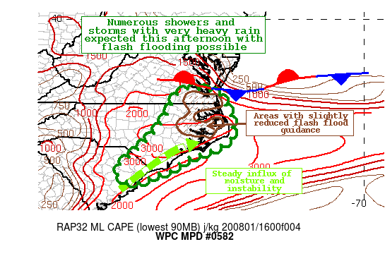
Areas affected...Northeast SC...Eastern NC...Southeast VA

Concerning...Heavy rainfall...Flash flooding possible

Valid 011816Z - 020000Z

SUMMARY...Heavy showers and thunderstorms are expected to increase
in coverage this afternoon with rainfall rates up to three inches
per hour.  Flash flooding will be possible with the strongest
convection through early this evening.

DISCUSSION...GOES-16 visible satellite imagery is indicating
increasing cumulus clouds across much of the region and rapidly
developing storms over southeast North Carolina, and extending
into northeast South Carolina.  The environment is becoming quite
conducive to convection with surface dewpoints in the middle to
upper 70s for many areas, and mixed layer CAPE rising into the
2500 to 3500 J/kg range based on the latest SPC mesoanalysis.
Effective bulk shear on the order of 20 to 30 knots and nearly
unidirectional WSW flow in the 850-300 mb layer will help support
some convective training.  Precipitable water is also quite
elevated with values on the order of 2.0 to 2.3 inches, and all of
these factors may lead to hourly rainfall rates of 2 to 3 inches
per hour at times for some locations.

The latest suite of high res guidance, including the HRRR, are in
good agreement with patchy areas of 3 to 5 inch rainfall totals
through 8 pm, with much of this likely to fall within a three hour
period.  The latest HREF probabilities of 3 inches per hour
approach 25 percent for portions of eastern North Carolina, and 50
percent for 2 inches per hour.  In addition, six-hour QPF ending
at 8 pm is up to 50 percent for exceeding 5 year ARI values based
on the latest HREF.  Flash flooding will be possible where
convection becomes more persistent.

Hamrick

ATTN...WFO...AKQ...CAE...ILM...MHX...RAH...

ATTN...RFC...MARFC...SERFC...NWC...

LAT...LON   37187700 37127663 37077621 37007590 36647572
            36287552 35927539 35417535 35087551 34727613
            34557658 34417707 34207743 33917775 33687851
            33367911 33487975 33818003 34107989 34557932
            35317855 35967807 36967754
Last Updated: 216 PM EDT Sat Aug 01 2020
|


