| WPC Met Watch |
|
|
Mesoscale Precipitation Discussion: #0583 (2020) |
|
(Issued at 420 PM EDT Sat Aug 01 2020
) |
|
| MPD Selection |
|
|
|
|
|

Mesoscale Precipitation Discussion 0583
NWS Weather Prediction Center College Park MD
420 PM EDT Sat Aug 01 2020

Areas affected...northern KY, southern IN into OH

Concerning...Heavy rainfall...Flash flooding possible

Valid 012018Z - 020215Z

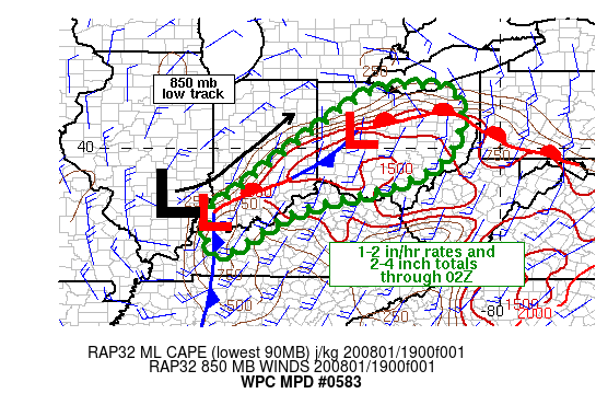
SUMMARY...Scattered areas of flash flooding will be possible
across portions of the OH Valley into northern OH through the
early evening. Rainfall rates of 1-2 in/hr are expected with 6
hour total rainfall in the 2-4 inch range through 02Z.

DISCUSSION...GOES East visible satellite imagery and surface
observations helped identify a stationary/warm front extending
from central OH into southern IN at 20Z. Two low pressure centers
were located along the front at with a cold front extending
southward from the western area of low pressure located in
southwestern IN. Clear to partly cloudy skies within the warm
sector has helped MLCAPE values to rise in the 500 to 1500 J/kg
range (estimates from SPC mesoanalysis page), although observed
MLCAPE from the special 18Z sounding at ILN was less than 250
J/kg. Special 18Z soundings from ILN and PIT showed precipitable
water values between 1.5 and 1.9 inches which appeared
representative of moisture values across the OH Valley given
recent GPS sensor readings.

Scattered thunderstorms were already present across IN/KY/OH, with
average cell motions of 10-25 kt from the SW or SSW, with higher
speeds toward the east. 850 mb winds from VAD wind plots and 18Z
area soundings showed a similar magnitude and direction to average
cell motions. Given the unidirectional flow from the SSW and the
frontal orientation more from SW to NE, training of cells has been
somewhat limited. However, as an 850 mb low located over southern
IL tracks toward the northeast over the next 6 hours, some veering
of the low level winds will allow for better directional alignment
with the quasi-stationary boundary, helping to support an
increased threat for repeating storms over the same location. The
thermodynamic environment is supportive of rainfall rates between
1-2 in/hr and with short term training and repeating, localized
totals of 2-4 inches in 2-3 hours will be possible. Flash flood
guidance values vary across the region but are as low as 1 inch in
3 hours for a few locations. Flash flooding will be possible
through 02Z.

Otto

ATTN...WFO...CLE...ILN...IND...IWX...LMK...PAH...PBZ...RLX...

ATTN...RFC...OHRFC...NWC...

LAT...LON   41568228 41538148 41128109 40458113 39638158
            39048278 38588467 38208569 37358702 37278757
            37938763 38408756 38708708 39268636 40258508
            41378345
Last Updated: 420 PM EDT Sat Aug 01 2020
|


