| WPC Met Watch |
|
|
Mesoscale Precipitation Discussion: #0585 (2020) |
|
(Issued at 530 AM EDT Sun Aug 02 2020
) |
|
| MPD Selection |
|
|
|
|
|

Mesoscale Precipitation Discussion 0585
NWS Weather Prediction Center College Park MD
530 AM EDT Sun Aug 02 2020

Areas affected...Eastern PA...Northern NJ...Far Southeast NY

Concerning...Heavy rainfall...Flash flooding possible

Valid 020930Z - 021430Z

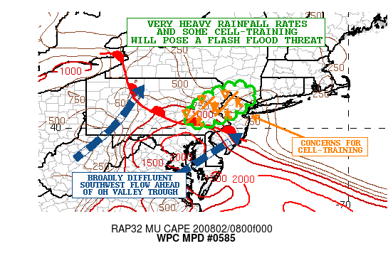
SUMMARY...Some training of showers and thunderstorms with very
heavy rainfall rates will pose a threat of flash flooding this
morning.

DISCUSSION...The latest radar imagery shows a small, broken
cluster of heavy showers and thunderstorms advancing northeast
through eastern PA. The activity is developing in relation to a
small-scale vort center embedded within a broad deep layer
southwest warm-air advection regime, and is rooted northeast of a
warm front within a pool of moderate elevated instability. MUCAPE
values are on the order of 1500 j/kg and the airmass is very moist
with PWs of 1.8 to 2 inches. The flow aloft over the northern
Mid-Atlantic region is also rather diffluent in connection to the
ejecting upper trough over the OH Valley which is fostering at
least some deeper layer ascent.

Over the next few hours, this activity should continue to advance
northeast and may tend to increase in coverage as somewhat
stronger southwest low-level flow impinges on the region and
fosters stronger low-level convergence/forcing near the front. In
fact, convective cloud tops have continued to cool over the last 1
to 2 hours with a gradual increase in coverage which is suggesting
stronger forcing overall. Generally, the threat for additional
heavy showers and thunderstorms will be over eastern PA, northern
NJ, and eventually far southeast NY including possibly parts of
the New York City metropolitan area.

The latest radar trends and output from the HRRR and
experimental-HRRR guidance is suggestive of some cell-training
going through the early morning hours as the convection becomes
aligned with the deeper layer southwest flow. Rainfall rates are
expected to be quite high given the deep moisture and instability
profiles, with rates locally exceeding 2 inches/hr. Some storm
total amounts through mid-morning of 3 to 4+ inches cannot be
ruled out and especially where any cell-training occurs. This will
drive a threat for flash flooding, and especially within any of
the more urbanized corridors.

Orrison

ATTN...WFO...ALY...BGM...CTP...OKX...PHI...

ATTN...RFC...MARFC...NERFC...NWC...

LAT...LON   41717427 41307382 40727444 40357524 40227579
            40157617 40257654 40637640 41087584 41597493
Last Updated: 530 AM EDT Sun Aug 02 2020
|


