| WPC Met Watch |
|
|
Mesoscale Precipitation Discussion: #0603 |
|
(Issued at 1215 PM EDT Sun Jul 06 2025
) |
|
| MPD Selection |
|
|
|
|
|

Mesoscale Precipitation Discussion 0603
NWS Weather Prediction Center College Park MD
1215 PM EDT Sun Jul 06 2025

Areas affected...Northern & Central Texas...

Concerning...Heavy rainfall...Flash flooding possible

Valid 061615Z - 062200Z

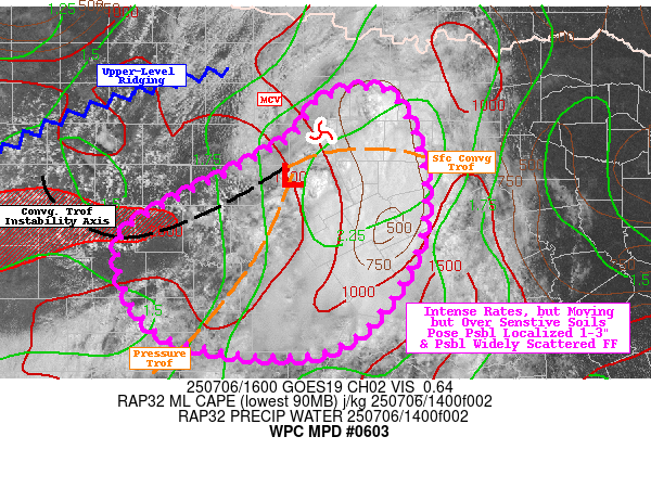
SUMMARY...Stubborn mid-level circulation and remaining tropical
moisture plume.

DISCUSSION...GOES-E WV suite shows favorable upper-level pattern
is breaking down a bit as 40-50kt jet streak and entrance region
shifts southward into central and southern TX with amplifying mid
to upper-level ridge across the Permian Basin sliding southeast
into the Big Country.  As such, very favorable outflow regime is
diminishing in influence and expected to slide.  A highly
stretched/sheared dryier axis exists across far E TX/LA;
corralling the remaining (but reducing) overall deep layer
moisture plume from the Red River Valley generally along I-35 and
westward through the eastern Hill country with values of 2-2.25"
remaining though mainly along the southeast quadrant of a
persistent/stubborm mid-level circulation centered near Palo Pinto
county.  The core of the deep layer moisture has seen a recent
rapid exhaustion of instability with the ongoing convective cores
that are erroding from Tarrent to Bosque county.

Surface, VWP and visible imagery analysis shows a convergence axis
of the western gradient of the deeper layer mositure from a weak
surface low near K6P9 back west across the Edwards Plateau from
Callahan to Coke to Sterling county.  Here, full insolation is
providing surface heating for narrow, skinny unstalbe profiles up
to 2000 J/kg; southwesterly to southerly flow along a pressure
trof from the low to JCT is providing the convergence necessary
for newer development.  Rainfall efficiency will continue to be an
issue with 2-2.5"/hr probable.  However, given the shift of the
favorable outflow aloft and stronger southerly inflow, propagation
is likey to press cells south and westward toward the Hill
Country, but given motion, more than likely limit duration at any
given location to scattered 1-3" totals.  Still, remaining
sensitive soils and rapid run off still may result in possible
localized flash flooding conditions.

Gallina

ATTN...WFO...EWX...FWD...SJT...

ATTN...RFC...FWR...NWC...

LAT...LON   33329763 32969728 32109711 31259736 30519817
            30589966 31000023 31700038 32109983 32369933
            32629884 32879844 33179827
Download in GIS format: Shapefile
| KML
Last Updated: 1215 PM EDT Sun Jul 06 2025
|


