| WPC Met Watch |
|
|
Mesoscale Precipitation Discussion: #0604 |
|
(Issued at 153 PM EDT Sun Jul 06 2025
) |
|
| MPD Selection |
|
|
|
|
|

Mesoscale Precipitation Discussion 0604
NWS Weather Prediction Center College Park MD
153 PM EDT Sun Jul 06 2025

Areas affected...Central North Carolina... Far South-central
Virginia...

Concerning...Heavy rainfall...Flash flooding likely

Valid 061800Z - 070000Z

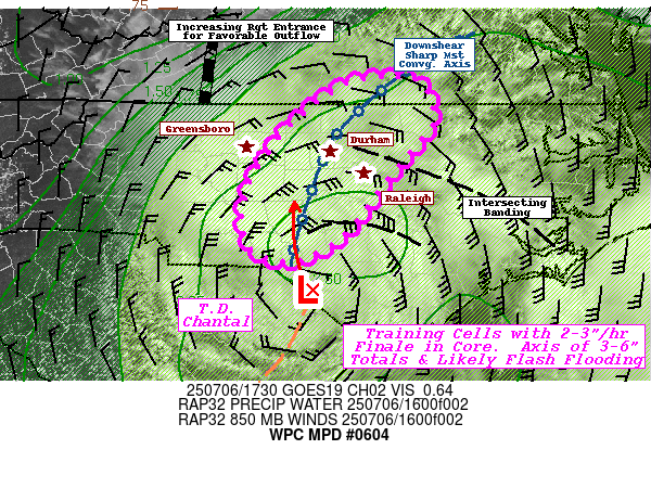
SUMMARY...Tropical Depression Chantal.  Prolonged moderate
rainfall with training core of intense rainfall of 2-3"/hr
possible.  Localized 3-6" and flash flooding likely.

DISCUSSION...GOES-E satellite suite shows classic vertical tilting
of the deep circulation of Chantal with broad surface/boundary
layer circulation becoming exposed along the southern and
southeastern side of the remaining strong convective core of
thunderstorms near Scotland/Richmond county expanding downshear
(north-northeastward) into Moore/Lee counties.  Upper-level speed
max is starting to increase connect up with the northern stream
main jet stream flow across the central Applachians; further
expanding downstream outflow aloft.  In doing so the mid to low
level circulation will continue to expand and elongate through a
deformation and low level convergence trough axis that can be seen
starting to become active with scattered showers from Orange to
Durham to Granville county area. Broad southeasterly to easterly
confluent 850-700mb 30-35kt flow slows and veers more northward
along this axis providing very strong moisture flux convergence
along it.

Cells will start with .5-1"/hr rates but increase as the
convective core lifts north, effectively training/repeating
through this same axis.  Given deepest moisture of 2.5-2.75" of
total PWats and strongest speed/directional convergence with the
850-700mb cyclone center will support initially 3"/hr rates slowly
reducing toward 2-2.5" toward 00z.  So prolonged moderate rainfall
amplifying to these higher rates will result in spotty 1-2" and
saturating wet grounds in advance of the intense rainfall; likely
limiting infiltration. Additional 2-4" totals along the
convergence zone results in an axis of 3-6" through 00z.  This
will likely result in flash flooding/rapid inundation conditions
along this narrow training corridor.  Current trends suggest axis
is likely across Moore to Chatham to Allamance and  may split
Greensboro and Raleigh metro areas, but small deviations of the
axis (more probable eastaward) would result in a growing concern
for considerable/significant flooding incidents due to urban
impermeable surfaces near those metro areas (incl.
Durham/Apex/Chapel Hill).

Gallina

ATTN...WFO...AKQ...RAH...RNK...

ATTN...RFC...ALR...NWC...

LAT...LON   36837859 36797809 36397792 36137811 35767841
            35207884 34887937 34997990 35577996 36127964
            36437935 36707898
Download in GIS format: Shapefile
| KML
Last Updated: 153 PM EDT Sun Jul 06 2025
|


