| WPC Met Watch |
|
|
Mesoscale Precipitation Discussion: #0607 (2019) |
|
(Issued at 1014 AM EDT Mon Jul 15 2019
) |
|
| MPD Selection |
|
|
|
|
|

Mesoscale Precipitation Discussion 0607
NWS Weather Prediction Center College Park MD
1014 AM EDT Mon Jul 15 2019

Areas affected...Southern/Central Louisiana...Western/Central
Mississippi

Concerning...Heavy rainfall...Flash flooding likely

Valid 151413Z - 152013Z

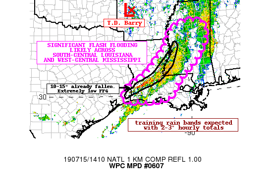
Summary...Dangerous, significant flash flooding is likely to
continue across south-central Louisiana into west-central
Mississippi as training rain bands associated with T.D. Barry
produce hourly totals 2-3". Additional rainfall through 20Z may
approach 5-8" locally.

Discussion...As of 14Z, radar imagery showed a persistent heavy
rainfall band oriented southwest to northeast across south-central
Louisiana into west-central Mississippi. Total rainfall amounts
locally across Avoyelles, Evangeline, Allen, Beauregard, and
Calcasieu parishes has reached 10-15 inches where significant
flash flooding has been occurring.

The environment will remain very conducive for significant heavy
rainfall and flash flooding into the afternoon hours. SBCAPE of
around 2000 J/kg exists across the outlook area within an axis of
highly anomalous moisture pool (2.2"+). The deep layer mean flow
across the region is oriented parallel to the storm cell motion
(southwest to northeast) and this suggests repeated, training
convection with rebuilding likely on the south/southwest flank
over the hardest hit areas already. All of the activity continues
to align itself along localized areas of stronger boundary layer
moisture convergence which is expected to persist through the
afternoon.

The latest HREF and other hi-res guidance shows stripes of heavy
rainfall to persist into the afternoon hours. The 06Z HREF 6-hour
mean shows widespread 2-4" amounts with local maximum totals in
the 5-8" range. This is likely to fall across areas that have
already seen the higher end totals (10-15") across south-central
Louisiana. Hourly totals are likely to be in the 2-3" range with
some extreme hourly totals near 4" possible given the deep
tropical moisture in place.

Dangerous, significant flash flooding is likely, especially across
south-central Louisiana given the already saturated soils. Flash
Flood Guidance for 1-hour is 0.25" or less, so this additional
rainfall will worsen ongoing flooding in the area.

Taylor

ATTN...WFO...JAN...LCH...LIX...MEG...SHV...

ATTN...RFC...LMRFC...SERFC...WGRFC...

LAT...LON   33818889 32838876 31808949 30659070 29899119
            29639229 29749318 29679349 29679399 29949426
            30259412 30639360 31259253 31889203 32449137
            33079115 33749046
Last Updated: 1014 AM EDT Mon Jul 15 2019
|


