| WPC Met Watch |
|
|
Mesoscale Precipitation Discussion: #0611 |
|
(Issued at 955 AM EDT Mon Jul 07 2025
) |
|
| MPD Selection |
|
|
|
|
|

Mesoscale Precipitation Discussion 0611
NWS Weather Prediction Center College Park MD
955 AM EDT Mon Jul 07 2025

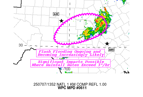
Areas affected...Parts of the Texas Hill Country

Concerning...Heavy rainfall...Flash flooding likely

Valid 071355Z - 071955Z

SUMMARY...Slow-moving thunderstorms producing local rainfall rates
over 3"/hr are ongoing and expected to continue through early this
afternoon. Some significant instances of flash flooding are
possible, especially given the sensitive flood-prone terrain of
central TX.

DISCUSSION...Radar and satellite imagery highlight strengthening
thunderstorms oriented along a strung-out 700 mb trough in a
west-southwest to east-northeast direction. MRMS estimates hourly
rainfall rates just west of Killeen over 3"/hr, with a HADS
observation (supprted by surrounding obs) recording 4.2" in 3
hours by 1330Z.

The same highly moist and unstable environment remains over
central TX, with mean layer flow generally less than 5 kts.
However, upwind propagation vectors remain out of the
north-northeast which supports back-building through this
afternoon. MLCAPE remains elevated in the 1000-1500 J/kg range and
will increase throughout the day due to the combination of
southerly flow out of the western Gulf and diurnal heating. This
setup supports the continuing threat of slow-moving thunderstorms
producing 2-3"+ hourly rates, with scattered flash flooding
likely. Significant flash flooding is also possible where any
mesoscale circulations develop within thunderstorms and can stall
these extreme rainfall rates over a region for a few hours (like
what was seen west of Killeen). Locally, rainfall totals may
exceed 5" within these intense thunderstorms.

1-hr FFG across the sensitive soils of central TX are generally
below 2" and as low as 1" locally. The 12z HRRR depicts convection
eventually migrating westward, probably under the influence of the
700 mb trough tilting west-east and lifting north. So, while the
ongoing activity will likely move within a few hours it can be
expected that scattered intense rainfall rates develop elsewhere
and lead to flash flooding.

Snell

ATTN...WFO...EWX...FWD...SJT...

ATTN...RFC...FWR...NWC...

LAT...LON   31739862 31509790 31039776 30649827 30309938
            30190046 30460087 31100046 31619958
Download in GIS format: Shapefile
| KML
Last Updated: 955 AM EDT Mon Jul 07 2025
|


