| WPC Met Watch |
|
|
Mesoscale Precipitation Discussion: #0613 |
|
(Issued at 156 PM EDT Mon Jul 07 2025
) |
|
| MPD Selection |
|
|
|
|
|

Mesoscale Precipitation Discussion 0613
NWS Weather Prediction Center College Park MD
156 PM EDT Mon Jul 07 2025

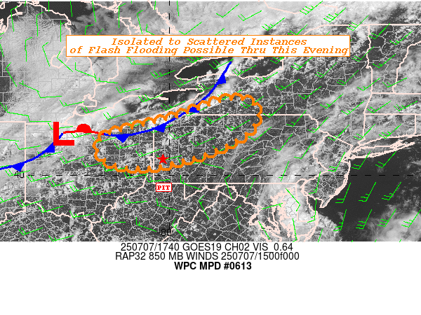
Areas affected...Parts of the Upper Ohio Valley

Concerning...Heavy rainfall...Flash flooding possible

Valid 071755Z - 072355Z

SUMMARY...A few instances of flash flooding are possible this
afternoon and evening across parts of the Upper Ohio Valley as
scattered thunderstorms contain the potential for 2"/hr rates and
may repeat over similar areas.

DISCUSSION...Radar and satellite observations this afternoon
highlight a cold front working its way slowly east-southeastward
along with an embedded low pressure area off the southwest shores
of Lake Erie as of 1730Z. Mean layer flow is quick (25-30kts) and
out of the southwest, leading to progressive storms along and
ahead of the frontal boundary. However, these storms are oriented
parallel to this flow, which supports the potential for repeating
rounds of storms that may lead to rainfall amounts exceeding local
FFG. PWs are greatest near and just ahead of the frontal boundary
where the best convergence is located, with values in the 1.7-2.0"
range and near the 90th climatological percentile per the 00z
ECENS. Daytime heating has also created an unstable environment
with SBCAPE values of 2500-3500 J/kg and should allow for the
coverage of thunderstorms to further increase this afternoon along
with increasing rainfall rates up to 2"/hr.

Local FFG in the usually sensitive terrain of the Upper Ohio
Valley and particularly western PA are around 1-2.5" per 1-hr and
2-3" per 3-hr. Recent 12z HREF guidance shows 40-50% chances for
exceeding 2" in 3-hr across northeast OH and northwest PA through
21z, which is where forecaster confidence is also highest for a
few instances of flash flooding due to repeating storms.

Snell

ATTN...WFO...BGM...BUF...CLE...CTP...PBZ...

ATTN...RFC...RHA...TAR...TIR...NWC...

LAT...LON   42527802 42357722 41737712 40957819 40427988
            40268119 40468206 40968240 41368201 41638087
            42007958
Download in GIS format: Shapefile
| KML
Last Updated: 156 PM EDT Mon Jul 07 2025
|


